
|
|
| DEUTSCHLAND | GERMANY | |
| Bundesland: Freistaat Bayern | Bavaria | |
Regierungsbezirk: Oberpfalz
| Landkreis: Cham
|
| |
map →

 Waldmünchen is situated at an elevation of 460–970 m in the Bayrischer Wald region close to the border to the Czech
Republic, about 18 km north-northeast of the district town Cham, about 60 km northeast of Regensburg,
the administrative centre of the Bavarian administrative region Oberpfalz, and about 161 km notheast of the Bavarian capital,
Munich. The municipality has a population of about 6,500 (2025).
Waldmünchen is situated at an elevation of 460–970 m in the Bayrischer Wald region close to the border to the Czech
Republic, about 18 km north-northeast of the district town Cham, about 60 km northeast of Regensburg,
the administrative centre of the Bavarian administrative region Oberpfalz, and about 161 km notheast of the Bavarian capital,
Munich. The municipality has a population of about 6,500 (2025).
The village Monacum was founded by monks, presumably from the monastery Walderbach. The dates that commonly are reported for this fact are either AD 910 or 923. In 1250, Monacum ante nemum Bohemorum obtained the status of a town, whose privileges were renewed in 1492. The town fortifications were first mentioned in 1364. Large parts of the surrounding area had to be ceded to Bohemia following the Border Treaty of Prague in 1764. The fortifications were torn down in 1839 and the town was connected to the railway lines in 1895. In 1968, Waldmünchen became officially recognized as a climatic spa.
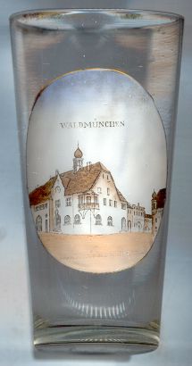
The origins of the  town hall of Waldmünchen [left] probably go back to 1492, when the
town's privileges were confirmed. The present building certainly had some previous structures in its place. After the large fires of
1658 and 1708, the town hall could only be rebuilt in 1717. The present building was erected in 1907. A recent extension was added in 1986.
town hall of Waldmünchen [left] probably go back to 1492, when the
town's privileges were confirmed. The present building certainly had some previous structures in its place. After the large fires of
1658 and 1708, the town hall could only be rebuilt in 1717. The present building was erected in 1907. A recent extension was added in 1986.
[https://de.wikipedia.org/wiki/Waldm%C3%BCnchen;
https://www.bayerischer-wald.de/attraktion/marktplatz-waldmuenchen-a8173fd8ed]
![[scale]](lineal.jpg)