
|
|
| ÖSTERREICH | AUSTRIA |
| Bundesland: Steiermark | Styria |
| Bezirk: Liezen |
map →

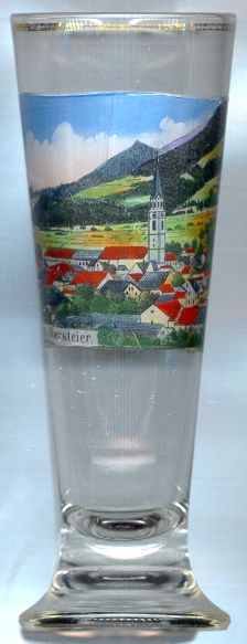
 Rottenmann is situated at an elevation of 681 m in the valley of the river Palten in Upper Styria.
Archeological finds demonstrate that the area was alrady inhabited in the Stone Ages. During the Roman times,
Rottenmann was the site of a road station (probably Stiriate) at the road from Virunum in Carinthia to the river Danube in the North.
The earliest written mention (praediolanum ad rotenmanum) dates from AD 927.
Around 1190, the new settlement was laid out as a fortified market. Parts of the fortifications including a tower with a gothic gateway are still preserved.
On the occasion of a visit of King Rudolf I of Habsburg in 1279, Rottenmann formally received the status of a town.
Since the mid-15th century, iron industry was a major economic factor of the town.
The modern development of Rottenmann began when it was connected to the railway line (Kronprinz-Rudolf-Bahn) from
St. Valentin (Upper Austria) and Amstetten (Lower Austria) to Ljubljana (Carniola, today Slovenia).
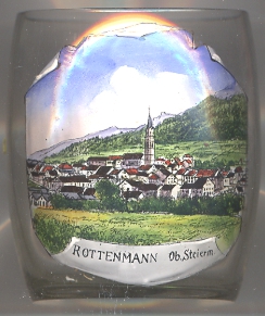
Rottenmann is situated at an elevation of 681 m in the valley of the river Palten in Upper Styria.
Archeological finds demonstrate that the area was alrady inhabited in the Stone Ages. During the Roman times,
Rottenmann was the site of a road station (probably Stiriate) at the road from Virunum in Carinthia to the river Danube in the North.
The earliest written mention (praediolanum ad rotenmanum) dates from AD 927.
Around 1190, the new settlement was laid out as a fortified market. Parts of the fortifications including a tower with a gothic gateway are still preserved.
On the occasion of a visit of King Rudolf I of Habsburg in 1279, Rottenmann formally received the status of a town.
Since the mid-15th century, iron industry was a major economic factor of the town.
The modern development of Rottenmann began when it was connected to the railway line (Kronprinz-Rudolf-Bahn) from
St. Valentin (Upper Austria) and Amstetten (Lower Austria) to Ljubljana (Carniola, today Slovenia).
The  parish church Sankt Nikolaus [centre] was first mentioned in 1226. Today's church was built in 1440 in
late Gothic style with frescos of 1509 and a marble pulpit of 1513. The magnificent high altar is decorated in Rococo style and holds altar pieces of
around 1770 painted by Martin Johann Schmidt (Kremser Schmidt). The organ was created in 1795 by Franz Xaver Chrisman, the most important organ builder of the 18th century.
parish church Sankt Nikolaus [centre] was first mentioned in 1226. Today's church was built in 1440 in
late Gothic style with frescos of 1509 and a marble pulpit of 1513. The magnificent high altar is decorated in Rococo style and holds altar pieces of
around 1770 painted by Martin Johann Schmidt (Kremser Schmidt). The organ was created in 1795 by Franz Xaver Chrisman, the most important organ builder of the 18th century.
![[scale]](lineal.jpg)