
|
|
| ÖSTERREICH | AUSTRIA |
| Bundesland: Niederösterreich | Lower Austria |
| Bezirk: Zwettl |
map →

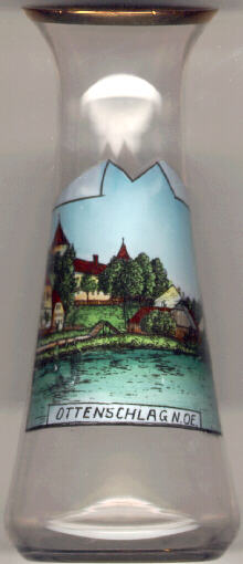 The market town Ottenschlag is situated at an elevation of 849 m in the southern Waldviertel region of Lower Austria.
It was presumably founded around 1240 (a document dated 1096 mentioning Ottenschlag proved to be a falsification)
and obtained the status of a market town prior to 1390.
It was the centre of the Lower Austrian peasants' uprising in 1596.
From 1938 until 1949 the communities of Ottenschlag, Haibach and Reichenau had a common burgomaster,
representing the three independent communes.
Since 1949, each community has its own burgomaster and municipal council, but all three communities have a common administration,
located in Reichenau.
The market town Ottenschlag is situated at an elevation of 849 m in the southern Waldviertel region of Lower Austria.
It was presumably founded around 1240 (a document dated 1096 mentioning Ottenschlag proved to be a falsification)
and obtained the status of a market town prior to 1390.
It was the centre of the Lower Austrian peasants' uprising in 1596.
From 1938 until 1949 the communities of Ottenschlag, Haibach and Reichenau had a common burgomaster,
representing the three independent communes.
Since 1949, each community has its own burgomaster and municipal council, but all three communities have a common administration,
located in Reichenau.
The  castle Ottenschlag was built starting from 1523 as a three-winged castle with three corner towers and a
Renaissance portal (1554) around the older, early medieval castle.
The old castle was demolished in the 18th century and its material was used to fill the old moat.
From 1931 until 1986 the castle was in possession of the monastery of Göttweig.
Today it is owned by the province of Lower Austria. It is used as a school and training centre.
castle Ottenschlag was built starting from 1523 as a three-winged castle with three corner towers and a
Renaissance portal (1554) around the older, early medieval castle.
The old castle was demolished in the 18th century and its material was used to fill the old moat.
From 1931 until 1986 the castle was in possession of the monastery of Göttweig.
Today it is owned by the province of Lower Austria. It is used as a school and training centre.
![[scale]](lineal.jpg)