
|
|
| ÖSTERREICH | AUSTRIA |
| Bundesland: Niederösterreich | Lower Austria |
| Bezirk: Korneuburg |
map →

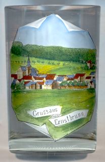 Ernstbrunn is situated at an elevation of 293 m in the southern part of the Leiser Berge nature reserve in the heart of the Weinviertel region of Lower Austria.
Ernustisprunnin was first mentioned in a document of 1045. The name refers to a spring (Brunnen = well,
spring), which some 400 years later, in 1432, was first mentioned as a place where people sook healing.
Ernstbrunn obtained the status of a market town in 1533. In 1828, the domains of Ernstbrunn came in possession of the princes
Reuß-Köstritz, a pariage of Reuß Junior Line (see Gera).
Important for the economical development during the late 19th century was the opening of the railway line
from Korneuburg via Ernstbrunn to Mistelbach in 1904/06.
The railroad was closed, however, in 1988.
Ernstbrunn is situated at an elevation of 293 m in the southern part of the Leiser Berge nature reserve in the heart of the Weinviertel region of Lower Austria.
Ernustisprunnin was first mentioned in a document of 1045. The name refers to a spring (Brunnen = well,
spring), which some 400 years later, in 1432, was first mentioned as a place where people sook healing.
Ernstbrunn obtained the status of a market town in 1533. In 1828, the domains of Ernstbrunn came in possession of the princes
Reuß-Köstritz, a pariage of Reuß Junior Line (see Gera).
Important for the economical development during the late 19th century was the opening of the railway line
from Korneuburg via Ernstbrunn to Mistelbach in 1904/06.
The railroad was closed, however, in 1988.
The  parish church Sankt Martin [left] was first mentioned in 1045/55.
The present church was built in the first half of the 18th century in Baroque style. The chancel and the east tower still date from the Gothic period.
parish church Sankt Martin [left] was first mentioned in 1045/55.
The present church was built in the first half of the 18th century in Baroque style. The chancel and the east tower still date from the Gothic period.
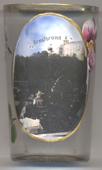
Ernstbrunn castle is located on the Semmelberg mountain. The oldest part of the castle dates from the 12th and 13th
century and is located on the rock promontory that dominates the village of Dörfles.
Further courtyards were added in the late Renaissance, Baroque and Classicist periods. The castle's park was originally
laid out in the second half of the 17th century and was transformed to an English landscape park during the 1860s by the
Prince of Reuß; in its northern part a wildlife park was created in 1975, which since 2009 also is home of the
Wolf Science Center, originally founded in 2008 in Grünau im Almtal.
Today, the castle is still in possession of the family Reuß-Köstritz.
The chapel of Our Lady in the village of Dörfles [bottom left]
was built in 1893.
[https://de.wikipedia.org/wiki/Ernstbrunn; https://de.wikipedia.org/wiki/Schloss_Ernstbrunn;
https://de.wikipedia.org/wiki/Liste_der_denkmalgeschützten_Objekte_in_Ernstbrunn]
![[scale]](lineal.jpg)