
|
|
| DEUTSCHLAND | GERMANY |
| Bundesland: Freistaat Thüringen | Thuringia |
| Landkreis: Saale-Orla-Kreis |
map →
 Triptis is situated at an elevation of 376 m in eastern Thuringia.
It was first mentioned in a document of 1212. In 1328 it was first mentioned as a town.
In 1485 it came into possession of the Ernestine branch of the Wettin family,
in 1571 in became part of the Electorate of Saxony (Albertine line of the House of Wettin).
For a short period, from 1657 until 1718, it was part of the Principality of Saxe-Zeitz.
After the Congress of Vienna, 1815, Triptis became part of Prussia, but just a few months later
became part of the Grand Duchy of Saxe-Weimar-Eisenach
where it remained until the foundation of Thuringia in1920.
Triptis is situated at an elevation of 376 m in eastern Thuringia.
It was first mentioned in a document of 1212. In 1328 it was first mentioned as a town.
In 1485 it came into possession of the Ernestine branch of the Wettin family,
in 1571 in became part of the Electorate of Saxony (Albertine line of the House of Wettin).
For a short period, from 1657 until 1718, it was part of the Principality of Saxe-Zeitz.
After the Congress of Vienna, 1815, Triptis became part of Prussia, but just a few months later
became part of the Grand Duchy of Saxe-Weimar-Eisenach
where it remained until the foundation of Thuringia in1920.
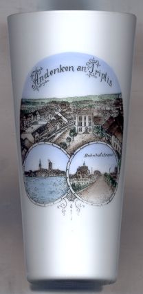
The  old town hall [top picture, centre] was built in 1853–1856 in Neo-Gothic style.
At the end of World War II, the town hall was destroyed by bombs just six days before the American troops entered Triptis.
Fifty years later, in 1995, the new town hall, built on the same spot, was opened.
old town hall [top picture, centre] was built in 1853–1856 in Neo-Gothic style.
At the end of World War II, the town hall was destroyed by bombs just six days before the American troops entered Triptis.
Fifty years later, in 1995, the new town hall, built on the same spot, was opened.
On the bottom left picture one can make out two towers. The left one is the tower of the town church Sankt Marien.
The right tower is the Schlossturm, the keep and only remainder of an old castle of the 15h century.
The bottom right picture shows the Bahnhofstraße. The street was named after the railroad station (Bahnhof) which was built
when the first railroad reached Triptis in 1869/71. Further lines were built during the following two decades and made Triptis a railroad junction. The old
railway station was destroyed in 1945.
![[scale]](lineal.jpg)