
|
|
| DEUTSCHLAND | GERMANY |
| Bundesland: Freistaat Sachsen | Saxony |
| Landkreis: Zwickau |
map →

 Glauchau, the district town of the district Chemnitzer Land is situated at an elevation of 283 m on the river
Zwickauer Mulde in the district Chemnitzer Land of Germany's state of Saxony.
Its origins go back to the castle of the lords of Schönburg (later counts of Schönburg-Glauchau), which was built around 1170/1180.
The town church St. Georgen was first mentioned in 1256. By 1335 Glauchau had obtained the status of a town.
Since the early 15th century clothmaking and weaving were important economic factors for the town.
The first spinning factory was opened in 1846, the first factory with mechanical looms opened in 1864.
Glauchau, the district town of the district Chemnitzer Land is situated at an elevation of 283 m on the river
Zwickauer Mulde in the district Chemnitzer Land of Germany's state of Saxony.
Its origins go back to the castle of the lords of Schönburg (later counts of Schönburg-Glauchau), which was built around 1170/1180.
The town church St. Georgen was first mentioned in 1256. By 1335 Glauchau had obtained the status of a town.
Since the early 15th century clothmaking and weaving were important economic factors for the town.
The first spinning factory was opened in 1846, the first factory with mechanical looms opened in 1864.
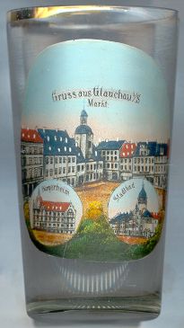
The  Rathaus (town hall) [top picture: centre] obtained its
present appearance in 1818. The first town hall of Glauchau had been constructed in 1440. The belfry of
the town hall contains a carillon made from porcellain from Meißen. It is played three times each day.
Rathaus (town hall) [top picture: centre] obtained its
present appearance in 1818. The first town hall of Glauchau had been constructed in 1440. The belfry of
the town hall contains a carillon made from porcellain from Meißen. It is played three times each day.
The Bürgerheim (former König-Albert-Stift) [bottom left] was built as a home for senior citizens
in the second half of the 19th century. It is still in use for the same purpose.
The Stadtbad (municipal baths) [bottom right] was built in 1904/1908.
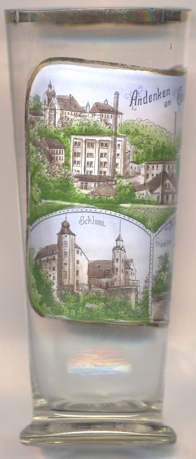
Glauchau castle [left, no. 4013: bottom left picture]
was founded by the lords of Schönburg around 1170/1180. Later on, the medieval castles was converted into a residential
castle in late Gothic style. The Renaissance castle Hinterglauchau was built from 1470 on the site of this old castle.
Further extensions, named Vorderglauchau were added in 1527–1524; at the same time the main castle was remodeled.
Around 1720 two rooms of the upper floor of the east wing were remodeled in Baroque style. Extensive renovations were carried out
in the 18th century. A low south wing was added in Historistic Tudor style in 1864&ndas;1865. Parts of the castle were used as
a museum (today, the Museum and Art Collection Schloss Hinterglauchau) as early as the 1930s.
[https://second.wiki/wiki/schloss_hinterglauchau]
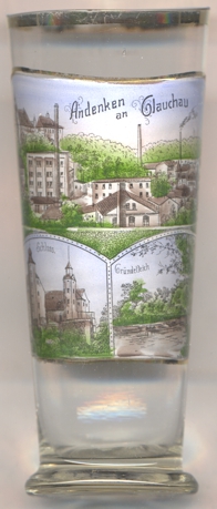
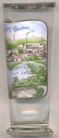
The bottom right picture on glass no. 4013 [left] shows a view of the
Gründelteich
[https://www.glauchau.de/glauchau/module/sb/17122003150725.asp?action=detail&id=5254]
The mineralogist, physician, politician, teacher and historian Georgius AGRICOLA (1494–1555) was born in Glauchau.
He attended schools in Glauchau, Chemnitz and Magdeburg,
and then studied at the university of Leipzig and worked as a teacher at Zwickau.
After his return from a journey to Italy, where he graduated, he returned to Saxony and worked as a physician in
Joachimsthal (now Jáchymov, CZ) and in Chemnitz where he also became burgomaster.
His fame is based on his books on grammatics, mineralogy, mining and history, which he published under his assumed name Agricola, the Latin
translation of his real name, Pawer (Bauer = engl. farmer). After his death he was buried in the cathedral of Zeitz.
His most important book, De re metallica, which he had finished in 1551, was only published in 1556, one year after his death.
![[scale]](lineal.jpg)