
|
|
| DEUTSCHLAND | GERMANY |
| Bundesland: Freistaat Thüringen | Thuringia |
| Landkreis: Gotha |
map →
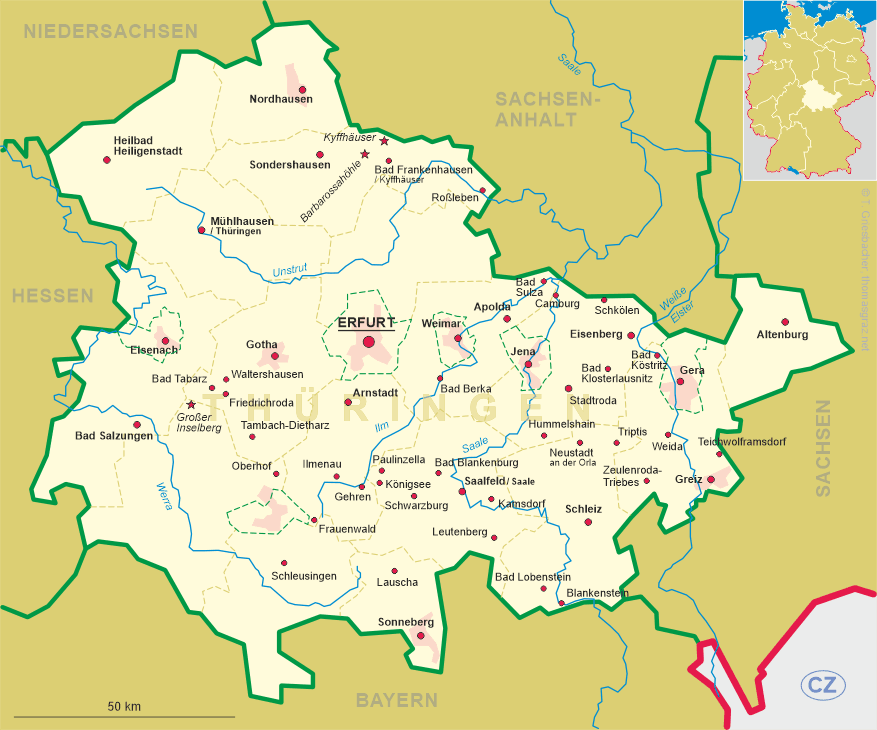

 Tambach-Dietharz is situated at an elevation of 450–886 m at the possibly oldest
pass road in the Thüringer Wald mountain region in the district Gotha.
Tambach-Dietharz is situated at an elevation of 450–886 m at the possibly oldest
pass road in the Thüringer Wald mountain region in the district Gotha.
The oldest written document that mentions Dambahc dates from 1039. As early as the 10th and 11th centuries, a trade and military route probably led through the Tambach basin over the ridge of the Thuringian Forest to Franconia with a connection to the southern German road network; the importance of this route peaked in the 14th and 15th centuries. In 1293, the lords of Meldingen donated the village to the monastery of Georgenthal. When the monastery was dissolved, the village from 1531 onward was part of the district Georgenthal, which since 1640 was part of the duchy of Saxe-Gotha. In 1919, Tambach and the neighbouring Dietharz were merged into the new municipality of Tambach-Dietharz, which in 1925 obtained the status of a town.
The Protestant  Lutherkirche goes back to a church built in 1350. In 1537 it was visited by the reformer Martin Luther
on his return journey from Schmalkalden to Wittenberg. The church was severely damaged by fires in 1684 and 1842, and only the
massive walls of the nave and the lower part of the church tower have remained of this old edifice. The present church was consecrated in 1844, the
tower was completed in 1861 but had to be rebuilt in 1883 when a new set of bells was installed. Damaged in 1945 and later infested by dry rot.
From 1972 to 1976 a community center was built on the ground floor, and above it the new church hall.
Lutherkirche goes back to a church built in 1350. In 1537 it was visited by the reformer Martin Luther
on his return journey from Schmalkalden to Wittenberg. The church was severely damaged by fires in 1684 and 1842, and only the
massive walls of the nave and the lower part of the church tower have remained of this old edifice. The present church was consecrated in 1844, the
tower was completed in 1861 but had to be rebuilt in 1883 when a new set of bells was installed. Damaged in 1945 and later infested by dry rot.
From 1972 to 1976 a community center was built on the ground floor, and above it the new church hall.

The Tambacher Talsperre [near left, no. 1446] was built in
1902–1905 and is the oldest river dam in Thuringia. With a height of 75 m it is
still one of the highest dams in the world.
[https://de.wikipedia.org/wiki/Tambach-Dietharz;
https://www.thueringer-wald.com/urlaub-wandern-winter/martin-luther-weg-123743.html]
![[scale]](lineal.jpg)