
|
|
| DEUTSCHLAND | GERMANY |
| Bundesland: Freistaat Sachsen | Saxony |
| Landkreis: Zwickau |
map →

 Crimmitschau is situated at an elevation of 268 m in western Saxony close to the border to Thuringia.
The settlement was founded around 1150 and was first mentioned in a document in 1212. Crimmitschau was chartered as a town in 1414.
Since the 15th century clothmaking was the main economic factor for the town. During the Thirty Years' War (1618–1648)
Crimmitschau was looted and burnt down repeatedly.The industrialisation began in the 19th century. In 1841 the town became independent
from the former feudal domain. In 1844 Crimmitschau was connected to the railway line to Altenburg.
During World War II the town was hit once by a bomb raid. In April 1945 Crimmitschau was liberated by the American army.
In July of the same year the town became part of the Soviet occupation zone. After the re-unification of Germany and the
administrative reform of 1994 the town became part of Saxony's district Zwickauer Land (since 2008 district
Zwickau).
Crimmitschau is situated at an elevation of 268 m in western Saxony close to the border to Thuringia.
The settlement was founded around 1150 and was first mentioned in a document in 1212. Crimmitschau was chartered as a town in 1414.
Since the 15th century clothmaking was the main economic factor for the town. During the Thirty Years' War (1618–1648)
Crimmitschau was looted and burnt down repeatedly.The industrialisation began in the 19th century. In 1841 the town became independent
from the former feudal domain. In 1844 Crimmitschau was connected to the railway line to Altenburg.
During World War II the town was hit once by a bomb raid. In April 1945 Crimmitschau was liberated by the American army.
In July of the same year the town became part of the Soviet occupation zone. After the re-unification of Germany and the
administrative reform of 1994 the town became part of Saxony's district Zwickauer Land (since 2008 district
Zwickau).
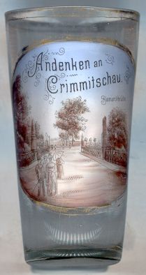
The picture on glass no. 1466 [left] shows the
 Bismarckbrücke
Several glasses of this collection show other Bismarck monuments.
![[scale]](lineal.jpg)