
|
|
| FRANCE | FRANCE |
| région: Grand Est | |
| département: 57, Moselle |
map →
 Saint-Avold is situated at an elevation of 234 m in the former région Lorraine (département Moselle) close to the border to Germany opposite Saarbrücken.
In 509 an Irish monk from Poitiers founded a shrine which became known as Hilariacum.
Around 720 the bishop of Metz founded an abbey which later became a Benedictine monastery.
In 765 relics of St. Nabor were brought here from Milan, which initiated the development of a small township.
(The name of the town, St. Avold, is a linguistic deformation of the original name St. Nabor.)
In 1163 St. Avold and the surrounding area was entrusted to the counts of Saarbrücken (Sarrebruck) and the town became an active
commercial centre of the area.
In 1581 St. Avold became part of the duchy of Lorraine. During the Thirty Years' War (1618–1648) the town was
occupied and looted several times by the various war parties. After the war the place was nearly deserted. In 1656 ony eighteen (!) inhabitants were
left over from a population of about 1,800 who lived here before the war. In the early 18th century the town was rebuilt and could resume its
commercial activities. During the times of the French Revolution, St. Avold was renamed Rosselgène in 1793.
The industrialisation began in the early 19th century and was further boosted by the opening of the railroads to
Metz in 1851 and to Saarbrücken in 1852.
The discovery of coal deposits had a great influence on the economy of the town just as in the rest of the eastern Moselle region.
In 1870 St. Avold together with Lorraine became part of Germany and remained so until the end of the German empire in 1918.
During that period St. Avold became a garrison town and retained that character even after World War I.
As St. Avold was situated close to the Maginot line many industrialists shied away from the town that was situated so close to a potential front line.
Indeed, St. Avold suffered heavily during World War II. During the war it had been annexed again by Germany
but was liberated by the American army in 1944.
Since then, St. Avold is the site of the largest cemetary of U.S. soldiers in Europe with more than 10,000 tombs.
After the war, the chemical and petrochemical industry became an important factor. Today St. Avold has a population of about 17,500.
Saint-Avold is situated at an elevation of 234 m in the former région Lorraine (département Moselle) close to the border to Germany opposite Saarbrücken.
In 509 an Irish monk from Poitiers founded a shrine which became known as Hilariacum.
Around 720 the bishop of Metz founded an abbey which later became a Benedictine monastery.
In 765 relics of St. Nabor were brought here from Milan, which initiated the development of a small township.
(The name of the town, St. Avold, is a linguistic deformation of the original name St. Nabor.)
In 1163 St. Avold and the surrounding area was entrusted to the counts of Saarbrücken (Sarrebruck) and the town became an active
commercial centre of the area.
In 1581 St. Avold became part of the duchy of Lorraine. During the Thirty Years' War (1618–1648) the town was
occupied and looted several times by the various war parties. After the war the place was nearly deserted. In 1656 ony eighteen (!) inhabitants were
left over from a population of about 1,800 who lived here before the war. In the early 18th century the town was rebuilt and could resume its
commercial activities. During the times of the French Revolution, St. Avold was renamed Rosselgène in 1793.
The industrialisation began in the early 19th century and was further boosted by the opening of the railroads to
Metz in 1851 and to Saarbrücken in 1852.
The discovery of coal deposits had a great influence on the economy of the town just as in the rest of the eastern Moselle region.
In 1870 St. Avold together with Lorraine became part of Germany and remained so until the end of the German empire in 1918.
During that period St. Avold became a garrison town and retained that character even after World War I.
As St. Avold was situated close to the Maginot line many industrialists shied away from the town that was situated so close to a potential front line.
Indeed, St. Avold suffered heavily during World War II. During the war it had been annexed again by Germany
but was liberated by the American army in 1944.
Since then, St. Avold is the site of the largest cemetary of U.S. soldiers in Europe with more than 10,000 tombs.
After the war, the chemical and petrochemical industry became an important factor. Today St. Avold has a population of about 17,500.
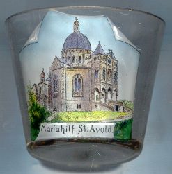
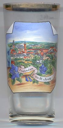
The picture on glass no. 1467 [near left] shows the
 Basilica
(See also list of other basilicae minores depicted on glasses of this collection.)

![[scale]](lineal.jpg)