
|
|
| ÖSTERREICH | AUSTRIA |
| Bundesland: Oberösterreich | Upper Austria |
| Bezirk: Rohrbach |
map →
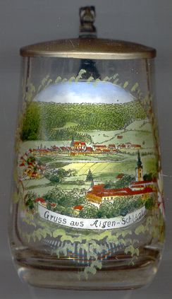 Aigen im Mühlkreis [background] is situated at an elevation of 596 m on the river Große Mühl in northern Upper Austria.
The place began to develop around 1240 as a trading place at a road to Bohemia, protected by the monastery of
Schlägl [foreground right].
The first mention of Aigen is found in a document of 1314. In 1362 Aigen obtained the status of a market town. After World War II
Aigen and Schlägl grew together, but still remain two independent municipalities. Today Aigen has a population of about 1,900 inhabitants.
Aigen im Mühlkreis [background] is situated at an elevation of 596 m on the river Große Mühl in northern Upper Austria.
The place began to develop around 1240 as a trading place at a road to Bohemia, protected by the monastery of
Schlägl [foreground right].
The first mention of Aigen is found in a document of 1314. In 1362 Aigen obtained the status of a market town. After World War II
Aigen and Schlägl grew together, but still remain two independent municipalities. Today Aigen has a population of about 1,900 inhabitants.
The  parish church Heiliger Evangelist und Apostel Johannes [background centre]
was built in 1897–1901 in Neo-Gothic style. Its large dimensions (35 m long, 21 m wide) are unusual for a community
of this small size. The large main altar from Carrara marble also is a rare example of Historicist art.
parish church Heiliger Evangelist und Apostel Johannes [background centre]
was built in 1897–1901 in Neo-Gothic style. Its large dimensions (35 m long, 21 m wide) are unusual for a community
of this small size. The large main altar from Carrara marble also is a rare example of Historicist art.
![[scale]](lineal.jpg)