
|
|
| DEUTSCHLAND | GERMANY |
| Bundesland: Freistaat Thüringen | Thuringia |
| Landkreis: Saalfeld-Rudolstadt |
map →
Saalfeld / Saale is situated at an elevation of 235 m on the river Saale in southern Thuringia. The municipality has a population of about 25,000 (2015).
 Saalfeld was first mentioned in a document of AD 899. When a Benedictine monastery was founded here in 1071/1074
by the archbishop of Cologne Saalfeld soon became a centre of ecclesiastical power
in eastern Thuringia. In 1180 Saalfeld was chartered as a town. The charter was the first in Thuringia
written in German. In 1572 Saalfeld came in possession of the dukes of Saxe-Weimar (see chart of the Wettin dynasty), in 1603 it passed to
Saxe-Altenburg, and in 1673 to Saxe-Gotha. In 1680 it became the residence of the non-sovereign line of Saxe-Saalfeld.
When the (sovereign) line of Saxe-Coburg became extinct in 1699, the line of Saxe-Saalfeld inherited
the Coburg rights of sovereignty in 1717. When Saxe-Saalfeld also obtained most of the Coburg countries in 1735
the line was called Saxe-Coburg-Saalfeld and the residence was moved to Coburg. After the reorganization of the Ernestine duchies in 1826
the Saalfeld parts of the duchy were given to Saxe-Meiningen while the duke of Saxe-Coburg obtained Gotha
as a second country and thus founded the line Saxe-Coburg and Gotha. After the abdication of the last
duke of Saxe-Meiningen in 1918 Saalfeld became part of the newly-founded state of Thuringia in 1920.
Saalfeld was first mentioned in a document of AD 899. When a Benedictine monastery was founded here in 1071/1074
by the archbishop of Cologne Saalfeld soon became a centre of ecclesiastical power
in eastern Thuringia. In 1180 Saalfeld was chartered as a town. The charter was the first in Thuringia
written in German. In 1572 Saalfeld came in possession of the dukes of Saxe-Weimar (see chart of the Wettin dynasty), in 1603 it passed to
Saxe-Altenburg, and in 1673 to Saxe-Gotha. In 1680 it became the residence of the non-sovereign line of Saxe-Saalfeld.
When the (sovereign) line of Saxe-Coburg became extinct in 1699, the line of Saxe-Saalfeld inherited
the Coburg rights of sovereignty in 1717. When Saxe-Saalfeld also obtained most of the Coburg countries in 1735
the line was called Saxe-Coburg-Saalfeld and the residence was moved to Coburg. After the reorganization of the Ernestine duchies in 1826
the Saalfeld parts of the duchy were given to Saxe-Meiningen while the duke of Saxe-Coburg obtained Gotha
as a second country and thus founded the line Saxe-Coburg and Gotha. After the abdication of the last
duke of Saxe-Meiningen in 1918 Saalfeld became part of the newly-founded state of Thuringia in 1920.
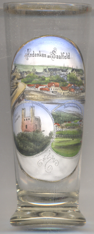
The  Hoher Schwarm [left, no. 3250: bottom left picture]
are the ruins of a castle above the town of Saalfeld. It was built in the Gothic period as a tower house by the
Counts of Schwarzburg. Destroyed in 1199, rebuilt thereafter but destroyed again in 1290
it was rebuilt around 1300. In 1389, still inhabitable, it was sold to the Wettin dynasty. At that time it was
generallly referred to as Sorbenburg. Used as an administrative seat, it lost its significance during the 15th
century and began to fall into dereliction. From 1551 onward, it was utilised as a quarry. The name Hoher Schwarm
first appeared in 1593, presumably a shortening of Schworbenburg or Sorbenburg. The remains of the
castle were secured in 1995–1997. The remains cover a quadratic ground plan with a side length 17 metres.
Originally, the castle had five storeys and, presumably, four round towers in each corner (of which only two remain today).
Hoher Schwarm [left, no. 3250: bottom left picture]
are the ruins of a castle above the town of Saalfeld. It was built in the Gothic period as a tower house by the
Counts of Schwarzburg. Destroyed in 1199, rebuilt thereafter but destroyed again in 1290
it was rebuilt around 1300. In 1389, still inhabitable, it was sold to the Wettin dynasty. At that time it was
generallly referred to as Sorbenburg. Used as an administrative seat, it lost its significance during the 15th
century and began to fall into dereliction. From 1551 onward, it was utilised as a quarry. The name Hoher Schwarm
first appeared in 1593, presumably a shortening of Schworbenburg or Sorbenburg. The remains of the
castle were secured in 1995–1997. The remains cover a quadratic ground plan with a side length 17 metres.
Originally, the castle had five storeys and, presumably, four round towers in each corner (of which only two remain today).
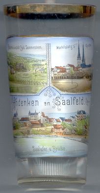
The church of St. Johannes [right, no. 1619: top right]
was built in Gothic style between 1380 and 1514 in place of an older, Romanesque church.
In 1524 the church became Protestant. Since 1678 it was used as the burial place of the dukes of Saxe-Saalfeld.
During the renovations in neo-Gothic style in 1891–1894 the towers were heightened to 63 m.
Renovations in 1983 aimed at restoring the original appearance.
The former Sanatorium Bad Sommerstein [left, no. 3250: bottom right picture,
and right, no. 1619: top left picture] in the western periphery of Saalfeld was built around 1870. The site consisted
of eight separate buildings with ca. 170 beds.
[https://de.wikipedia.org/wiki/Saalfeld/Saale, https://en.wikipedia.org/wiki/Saalfeld;
https://de.wikipedia.org/wiki/Hoher_Schwarm;
https://de.wikipedia.org/wiki/Johanneskirche_(Saalfeld);
http://www.rottenplaces.de/main/sanatorium-sommerstein-restgebaeude-2611/]
![[scale]](lineal.jpg)