
|
|
| DEUTSCHLAND | GERMANY |
| Bundesland: Baden-Württemberg | |
| Regierungsbezirk: Tübingen | |
| Landkreis: Reutlingen |
map →

Reutlingen is situated at an elevation of 380 m on the river Echatz between the Achalm at the foot of the Schwäbische Alb mountains. The earliest settlements were founded by the Alemanni in the 4th/5th century. The old castle on the Achalm was built around 1030. The oldest document mentioning Rutelingin is a contract dated to 1089/1090.
Around 1180 Reutlingen became a
market town and some time between 1220 and 1240 it was chartered as a town and received fortifications.
The landmark of Reutlingen, the Lady Church, was begun in 1343 but until the Reformation remained a filial church of the parish church
St Peter and Paul in der Weiden, which was located outside the town walls. In 1262 the town came into the
possession of the Counts of Württemberg. With the "privilegium fori" of 1337 Reutlingen obtained a status comparable to a Free Imperial Town,
although the right of full jurisdiction was only gained in the 15th century. After the defeat in 1388 of the Swabian league of towns Reutlingen
had to accept the supremacy of Württemberg. During the 14th and 15th century it remained one of the smaller Imperial towns.
The supremacy of Württemberg over Reutlingen was sealed in 1505 by a contract which was extended continuously until 1802.
After an unsuccessful raid on the town Duke Ulrich of Württemberg had to leave the country and only could return 15 years later.
The Reformation was introduced already in 1524, and in 1530 Reutlingen was the only Imperial town beside Nuremberg
to sign the Confession Augustana. Until 1802 it was required to be Protestant to gain citizenship in Reutlingen.
The Thirty Years' War (1618–1848) caused severe damages and the town was forced to sell off parts of its domains to Württemberg. The large fire of 1726 destroyed large parts of the town. After the Reichsdeputationshauptschluss of 1802/1803 Reutlingen lost its independence and became part of the Duchy (1806 Kingdom) of Württemberg. In 1818 it became the administrative seat of the Schwarzwald (Black Forest) district. The opening of the railroad from Plochingen to Reutlingen initiated the period of industrial growth. After three Allied bomb raids in 1945 Reutlingen was one of the ten most heavily damaged cities in Baden and Württemberg. Today Reutlingen is the seat of the Reutlingen district and has a population of 110,000 (2004).
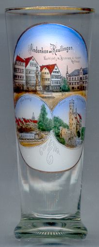
The top picture on glass no. 1664 shows the  market
The 'new'
The market
The quarter Klein-Venedig (Little Venice) [bottom left picture]
along the river once was the home of tanners. The picturesque houses have long disappeared.
The bottom right picture shows Lichtenstein castle, about 17 km southeast of Reutlingen.
![[scale]](lineal.jpg)