
|
|
| DEUTSCHLAND | GERMANY |
| Bundesland: Freistaat Bayern | Bavaria |
| Regierungsbezirk: Schwaben | |
| Landkreis: Donau-Ries |
map →

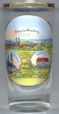 Wemding is situated at an elevation of 479 m at the eastern edge of the Ries plane, which had been formed
some 15 million years ago by the impact of a meteorite. The town is the leading tourist place of northern Swabia.
The place was first mentioned in a document of AD 793 as Uuemodinga. In 1348 Wemding was chartered as a town.
Around 1500/1503 the old, Alemannic, name Wemodingen changed to the Bavaric form, Wembding.
Wemding is situated at an elevation of 479 m at the eastern edge of the Ries plane, which had been formed
some 15 million years ago by the impact of a meteorite. The town is the leading tourist place of northern Swabia.
The place was first mentioned in a document of AD 793 as Uuemodinga. In 1348 Wemding was chartered as a town.
Around 1500/1503 the old, Alemannic, name Wemodingen changed to the Bavaric form, Wembding.
The  parish church Sankt Emmeram [left] is the oldest church of Wemding.
The oldest church on this place, a Romanesque three-naved construction, was built in 1030–1060.
The choir (presbytery) was rebuilt in Gothic style in 1307/1308. The naves were heightened in the Baroque period (17th century).
The two mighty towers (65 m high, nicknamed the 'unequal brothers') are the landmark of Wemding.
A treasure of the church is the main altar of the Renaissance period, completed in 1633. A fresco in the presbytery
dates from 1430.
parish church Sankt Emmeram [left] is the oldest church of Wemding.
The oldest church on this place, a Romanesque three-naved construction, was built in 1030–1060.
The choir (presbytery) was rebuilt in Gothic style in 1307/1308. The naves were heightened in the Baroque period (17th century).
The two mighty towers (65 m high, nicknamed the 'unequal brothers') are the landmark of Wemding.
A treasure of the church is the main altar of the Renaissance period, completed in 1633. A fresco in the presbytery
dates from 1430.
The bottom right picture shows a building labeled 'Bad Wemding' (Wemding spa).
The oldest documented mention of a bathhouse dates from 1449. The spa was rebuilt in 1559.
The building shown on the glass dates from the 19th century.
![[scale]](lineal.jpg)