
|
|
| ÖSTERREICH | AUSTRIA |
| Bundesland: Niederösterreich | Lower Austria |
| Stadt: Sankt Pölten |
map →

Sankt Pölten is situated at an elevation of 271 m on the river Traisen in central Lower Austria.
Between the 2nd and 4th centuries AD the place was the site of the Roman town Aelium Cetium. The first mention of Traisma or Treisma appears in a documents of 799 and 823, a document of 976 mentions Traisima ad monasterium Sancti Yppoliti. The name St. Pölten is derived from St. Hippolytus. St. Pölten acquired the privileges of a market town in 1050 and was chartered as a town in 1159. Until 1494 the town was in possession of the bishops of Passau and then became a property of Austrian sovereigns (at that time Emperor Maximilian I). In 1785 St. Pölten became the seat of a bishop. On the 10th of July 1989 the Lower Austrian parliament chose St. Pölten as the new capital of the province. In 1997 the government of Lower Austria finally moved from Vienna to St. Pölten.
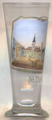
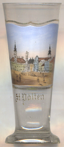
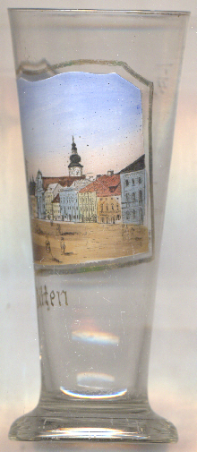
The  Rathaus (town hall) [left, no. 4939: background left]
was first mentioned in a written document in 1503 when the building was purchased by the town to serve as a town hall.
The western half was purchased in 1567 and the façade was unified. The octagonal town hall tower was completed in 1591.
The town hall acquired its current Baroque appearance in the first half of the 18th century. In 1727, the façade was
redesigned. The mayor's room, the former council chamber, and especially its imperial ceiling with medallion portraits of the
Holy Roman Emperors from Friedrich III to Karl VI, was decorated in 1722. The onion dome was added between 1750
and 1775.
Rathaus (town hall) [left, no. 4939: background left]
was first mentioned in a written document in 1503 when the building was purchased by the town to serve as a town hall.
The western half was purchased in 1567 and the façade was unified. The octagonal town hall tower was completed in 1591.
The town hall acquired its current Baroque appearance in the first half of the 18th century. In 1727, the façade was
redesigned. The mayor's room, the former council chamber, and especially its imperial ceiling with medallion portraits of the
Holy Roman Emperors from Friedrich III to Karl VI, was decorated in 1722. The onion dome was added between 1750
and 1775.
The Column of Our Lady [foreground] in the main square (Herrenplatz)
was was donated in 1717 by the owner of the house at Herrenplatz 2, as a result of a vow made during the plague of
1713/1714.
The cathedral of the Ascension of Our Lady [background right]
is the former abbey church of the monastery now housed in the diocese building. The ground plan largely dates back to the
building constructed around 1150. Originally built as a three-aisled church without a transept and featuring twin towers
as its westwork, it was extensively rebuilt between 1267 and 1280 in the Late Romanesque style. Today, the building is
characterized mainly by its Baroque features, particularly the imposing south tower with its double onion dome and the
cupola lanterns on the south aisle. The apse and the south façade are the only remaining elements of the Late
Romanesque structure. Since 1785 it serves as the cathedral of the Roman-Catholic diocese of Sankt Pölten.
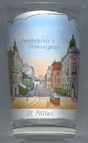
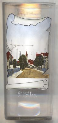
Glass no. 1736 [left] shows a view of
Bahnhofplatz Kremsergasse
[https://de.wikipedia.org/wiki/St._P%C3%B6lten;
https://de.wikipedia.org/wiki/Rathaus_St._P%C3%B6lten;
https://de.wikipedia.org/wiki/Liste_der_denkmalgesch%C3%BCtzten_Objekte_in_St._P%C3%B6lten_(Stadtteil)]
![[scale]](lineal.jpg)