
|
|
| DEUTSCHLAND | GERMANY |
| Bundesland: Rheinland-Pfalz | Rhineland-Palatinate |
| Landkreis: Bitburg-Prüm |
map →
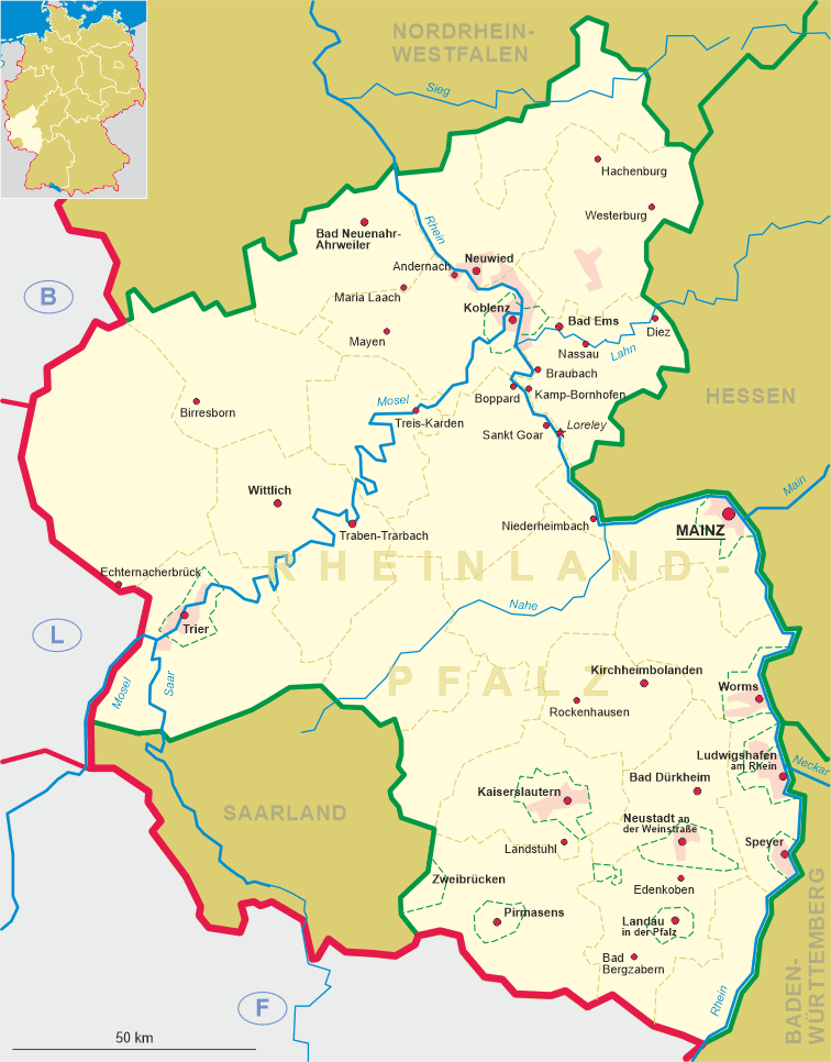
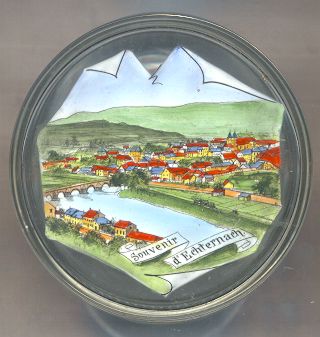
Echternacherbrück is situated at an elevation of 170 m on the left bank of the river Sauer (French: Sûre) which marks the border between Germany and Luxembourg. Glass jar no. 1851 [below] is a souvenir from Echternach (Luxembourg). Only the row of houses depicted in the foreground belong to the municipality of Echternacherbrück (Germany).
 The history of Echternacherbrück began in 1815 when the Congress of Vienna created the
Grand Duchy of Luxembourg. The Sauer river became the border between Luxembourg and the Prussian North Rhine province
so that a customs office was built in the same year at the Prussian side of the bridge which crossed the river at this point.
As the fields on the Prussian side remained in possession of Echternach citizens, some of them built new houses here.
The new settlement at first was called Echternacher Brücke (Echternach Bridge).
Until about 1850 it consisted of only 9 houses with about 50 inhabitants.
The development of the village took on speed in the second half of the 19th century when better roads were built and
Echternach was connected to the Luxembourg railroad system. In February 1945 Echternacherbrück was destroyed by 90%
when the American troops attempted to cross the Sauer river.
Today Echternacherbrück has about 680 inhabitants and is administered together with the municipality of Irrel.
The history of Echternacherbrück began in 1815 when the Congress of Vienna created the
Grand Duchy of Luxembourg. The Sauer river became the border between Luxembourg and the Prussian North Rhine province
so that a customs office was built in the same year at the Prussian side of the bridge which crossed the river at this point.
As the fields on the Prussian side remained in possession of Echternach citizens, some of them built new houses here.
The new settlement at first was called Echternacher Brücke (Echternach Bridge).
Until about 1850 it consisted of only 9 houses with about 50 inhabitants.
The development of the village took on speed in the second half of the 19th century when better roads were built and
Echternach was connected to the Luxembourg railroad system. In February 1945 Echternacherbrück was destroyed by 90%
when the American troops attempted to cross the Sauer river.
Today Echternacherbrück has about 680 inhabitants and is administered together with the municipality of Irrel.
Until the 19th century, the  bridge acrosse the river Sauer [left] was thought to be of Roman origin,
although proof for this assumption is absent. In the 16th and 17the century remains of Roman tombstones were discovered in the pillars of the bridge;
however it is more likely that they have been used as building material only. A painting of the bridge dating from the 17th century still shows it
with six arches. One of these, the last one on the Echternach side, was filled in in 1870 when the Prince Henry Railroad
(named for Prince Hendrik of Oranje-Nassau, governor of Luxembourg) was built. On 12 September 1944, the German Wehrmacht blew up the bridge.
After the war, a preliminary bridge was constructed just north of the remains of the old bridge. A new bridge was then constructed in 1950.
bridge acrosse the river Sauer [left] was thought to be of Roman origin,
although proof for this assumption is absent. In the 16th and 17the century remains of Roman tombstones were discovered in the pillars of the bridge;
however it is more likely that they have been used as building material only. A painting of the bridge dating from the 17th century still shows it
with six arches. One of these, the last one on the Echternach side, was filled in in 1870 when the Prince Henry Railroad
(named for Prince Hendrik of Oranje-Nassau, governor of Luxembourg) was built. On 12 September 1944, the German Wehrmacht blew up the bridge.
After the war, a preliminary bridge was constructed just north of the remains of the old bridge. A new bridge was then constructed in 1950.
![[scale]](lineal.jpg)