
|
|
| POLSKA | POLAND |
| województwo: Kujawsko-Pomorskie | voivodship: Kuyavia-Pomerania |
| powiat: Chełmno | county: Chełmno |
map →
Chełmno is situated at an elevation of 75 m just south of the river Wisła (Vistula, Weichsel) about 30 km northeast of Bydgoszcz. Chełmno is the seat of the administrative district of the same name (powiat chełmiński) and has a population of about 21,100 (2004).
 The first settlement on the St. Lawrence hill (Góra św. Wawrzyńca) originated in the 7th century. A basilica in
an important settlement of the Piast country was founded in the early 11th century near the nearby village of Kałdus.
The first mention of Chełmno (German Culm, Kulm) is found in a document of 1065. In 1215 the place became the seat of
the first bishop of Prussia and soon after that, in 1233, Culm was chartered as a town in the country of the
Teutonic Order and became the seat of the Chełmno district.
In 1440 the town joined the 'Prussian Union'. After the Second Peace of Toruń
which ended the war between the Teutonic Order and the Polish kingdom (Thirteen Years' War, 1453–1466)
the town was incorporated into Poland. The privileges of Chełmno
(Chełmno rights, Culmer Recht), which had been granted in 1233 and which were renewed in 1251, were
highly influencial throughout Poland and Prussia. The rights became a model system for the charters of more
than 200 other towns. After the First Partition of Poland in 1772 (see map)
Culm became part of Prussia. During the Napoleonic times Chełmno in 1807 became part of the
Duchy of Warsaw but was returned to Prussia by the Congress of Vienna
in 1815. After World War I Chełmno finally became part of Poland in 1920.
The first settlement on the St. Lawrence hill (Góra św. Wawrzyńca) originated in the 7th century. A basilica in
an important settlement of the Piast country was founded in the early 11th century near the nearby village of Kałdus.
The first mention of Chełmno (German Culm, Kulm) is found in a document of 1065. In 1215 the place became the seat of
the first bishop of Prussia and soon after that, in 1233, Culm was chartered as a town in the country of the
Teutonic Order and became the seat of the Chełmno district.
In 1440 the town joined the 'Prussian Union'. After the Second Peace of Toruń
which ended the war between the Teutonic Order and the Polish kingdom (Thirteen Years' War, 1453–1466)
the town was incorporated into Poland. The privileges of Chełmno
(Chełmno rights, Culmer Recht), which had been granted in 1233 and which were renewed in 1251, were
highly influencial throughout Poland and Prussia. The rights became a model system for the charters of more
than 200 other towns. After the First Partition of Poland in 1772 (see map)
Culm became part of Prussia. During the Napoleonic times Chełmno in 1807 became part of the
Duchy of Warsaw but was returned to Prussia by the Congress of Vienna
in 1815. After World War I Chełmno finally became part of Poland in 1920.
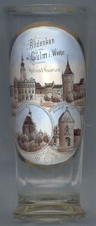
The oldest parts of the  town hall [top picture, left]
in the middle of the market square date from the end of the 13th century. The building was completely rebuilt in
Renaissance manneristic style in 1567–1572. The tower was added in 1584–1596 and received its Baroque roof
in 1721.
town hall [top picture, left]
in the middle of the market square date from the end of the 13th century. The building was completely rebuilt in
Renaissance manneristic style in 1567–1572. The tower was added in 1584–1596 and received its Baroque roof
in 1721.
The structure shown on the right of the top picture on glass no. 1497 shows the
water
The church of the Cistercian nunnery, dedicated to St. John the Baptist and
St. John the Evangelist was built in 1280–1330. It is a rare example of a church with two floors.
The ground floor was accessible for lay people whereas the upper floor was reserved for the nuns only. The
nunnery, which had been founded in 1261, was taken over by Benedictine nuns between 1429 and 1438. In 1822 the
complex was taken over by the Sisters of Mercy who renovated the structures in neo-Gothic style.
The Grudziądzka Gate [bottom right] is part of the
city's fortifications which are still preserved. The gate guarded the main access
into the city in the northeast, coming from Grudziądz. The present shape of the gate
was created in 1694 when a Renaissance chapel replaced the former drawbridge and an annex. The chapel prevented the gate
from being demolished in the 19th century.
![[scale]](lineal.jpg)