
|
|
| ČESKÁ REPUBLIKA | CZECH REPUBLIC |
| Olomoucký kraj | Olomouc region |
| Okres: Jeseník |
map →
Mikulovice is situated at an elevation of 420 m in the valley of the river Bělá at the northeatern edge of the Jeseníky mountains in the Jeseník district close to the border to Poland.
 Villa Nikolai was first mentioned in a document of 1263.
At that time the rivers Bělá and Olešnice were also used for washing gold.
In 1907 the village obtained the status of a market town and the neighbouring community of
Buchberg (Buchberk, now Bukovec) was incorporated into the new municipality (Markt Niklasdorf). In 1960,
Kolnovice (formerly Kohlsdorf) and Široký Brod (Breitenfurt) were also incorporated into Mikulovice.
Mikulovice obtained the status of a town in 1990.
Villa Nikolai was first mentioned in a document of 1263.
At that time the rivers Bělá and Olešnice were also used for washing gold.
In 1907 the village obtained the status of a market town and the neighbouring community of
Buchberg (Buchberk, now Bukovec) was incorporated into the new municipality (Markt Niklasdorf). In 1960,
Kolnovice (formerly Kohlsdorf) and Široký Brod (Breitenfurt) were also incorporated into Mikulovice.
Mikulovice obtained the status of a town in 1990.
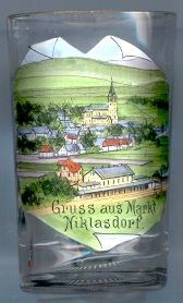
The picture on glass no. 1972 [left] shows the
 parish
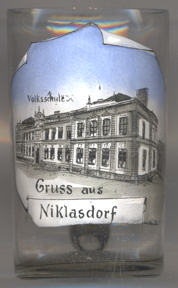
The picture on glass no. 3229 [right] shows the
municipal
Other glass(es) in this collection from places with the same name:
The previous German name Niklasdorf is also the name of Niklasdorf in Styria, Austria.
[https://de.wikipedia.org/wiki/Mikulovice_u_Jeseníku, https://en.wikipedia.org/wiki/Mikulovice_(Jeseník_District);
http://www.mikulovicezs.cz/index.php/historie]
![[scale]](lineal.jpg)