
|
|
| DEUTSCHLAND | GERMANY |
| Bundesland: Freistaat Bayern | Bavaria |
| Regierungsbezirk: Schwaben | |
| Landkreis: Donau-Ries |
map →

Donauwörth is situated at an elevation of 410 m where the river Wörnitz meets the Danube. Donauwörth is the administrative seat of the Donau-Ries district and has a population of about 18,200 (2002).
The earliest traces of a settlement on an island in the river Wörnitz in date from around 500.
Around 1000 the village obtained the rights of a market town.
The earliest written mention of Werd dates from 1030 when the privileges of the market town were confirmed
by Emperor Konrad II.
The monastery Heilig Kreuz was founded in 1047/49 and initiated a period of further growth.
The town, now named Schwäbischwerd, was chartered in 1090. The name later changed to
Thonauwörth before it finally mutated to the modern name, Donauwörth.
Between 1178 and 1268 Donauwörth was an Imperial fief in possession of the Hohenstaufen who in 1268
pawned it to the Dukes of Bavaria. Already in 1256, Donauwörth was the site of a sad historic incident.
Maria of Brabant, wife of Duke Ludwig I of Bavaria, was accused of adultery and was beheaded.
Every year, an open-air performance of a theatric play commemorates this event today.
In 1301, after the Peace of Bensheim, the town obtained the status of a Free Imperial City and thus was subject
only to the emperor. During the Reformation period Donauwörth supported the Protestant side. As a consequence,
the city was banned by the Empire in 1607 and was pawned to Bavaria which initiated a period of recatholisation.
Only between 1705 until the Peace of Baden (Aargau) in 1714
Donauwörth again enjoyed the status of a Free Imperial City before it was finally incorporated into Bavaria.
In 1847 Donauwörth was connected to the new railroad system. In 1850 the town became independent from the surrounding administrative district, but was re-integrated into the district in 1940. At the end of World War II, on the 11th and 12th of April 1945, about 75% of the city of Donauwörth were destroyed by Allied bomb raids and had to be rebuilt after the war. The neighbouring communities of Auchsesheim, Nordheim and Zirgesheim were incorporated into Donauwörth in 1971, Riedlingen and Zusum followed in 1972, Schäfstall and Wörnitzstein in 1978. Since 1973 the city is the administrative seat of the Donau-Ries district, which was formed by the combination of the former districts Nördlingen and Donauwörth. In 1998 Donauwörth obtained the status of a major district town (Große Kreisstadt).
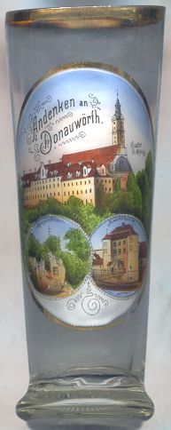
The history of the  monastery Heilig Kreuz [top picture]
goes back to the donation in 1029 of a particle of the Holy Crucifix to the nunnery on the Mangoldstein.
The relic was brought from Constantinople by Count Mangold I of Werd.
In 1047 the old monastery and church were consecrated by Pope Leo IX. This old monastery was destroyed
around 1067/1070 and was rebuilt in the plain below by Mangold II. A monastery for monks was founded in 1101 next to the nunnery.
In 1135 the nunnery was closed, the old privileges were transfered to the new convent which became a
Benedictine monastery. The new monastery church was consecrated in 1188.
The former Romanesque church was rebuilt in Gothic style in 1366. The monastery was completely rebuilt in 1696–1698.
The Gothic church was replaced by a new, Baroque church between 1717 and 1720. The interior decorations mostly date from
1723–1735.
After the Secularisation of 1803 the monastery was closed and all its assets were transferred to the Princes of
Oettingen-Wallerstein. The former monstery church remained in use as a parish church.
In 1877 the former monastery was converted into a school ('Cassianum').
Since 1910 it is in possession of the 'Pedagogic Foundation Cassianum'.
monastery Heilig Kreuz [top picture]
goes back to the donation in 1029 of a particle of the Holy Crucifix to the nunnery on the Mangoldstein.
The relic was brought from Constantinople by Count Mangold I of Werd.
In 1047 the old monastery and church were consecrated by Pope Leo IX. This old monastery was destroyed
around 1067/1070 and was rebuilt in the plain below by Mangold II. A monastery for monks was founded in 1101 next to the nunnery.
In 1135 the nunnery was closed, the old privileges were transfered to the new convent which became a
Benedictine monastery. The new monastery church was consecrated in 1188.
The former Romanesque church was rebuilt in Gothic style in 1366. The monastery was completely rebuilt in 1696–1698.
The Gothic church was replaced by a new, Baroque church between 1717 and 1720. The interior decorations mostly date from
1723–1735.
After the Secularisation of 1803 the monastery was closed and all its assets were transferred to the Princes of
Oettingen-Wallerstein. The former monstery church remained in use as a parish church.
In 1877 the former monastery was converted into a school ('Cassianum').
Since 1910 it is in possession of the 'Pedagogic Foundation Cassianum'.
Other places which claim one of the many reliquiaries of particles of the Holy Crucifix and of which there
are glasses in this collection are the
Cistercian abbeys of Heiligenkreuz and Lilienfeld (Austria),
the cathedral of Limburg a. d. Lahn (Germany) and the famous cathedral
Notre-Dame in Paris (France).
|
The cliff Mangoldfelsen [bottom left]
was the location of the oldest castle, founded probably in the early 10th century.
The castle was destroyed in 1070 during the Investiture Controversy. The open-air theatre at the foot of the cliff
each year is the site of theatre performances which re-enact the tragic end of Maria of Brabant.
The cliff is named for Mangold I of Werd who had brought the relic of the Holy Crucifix from Constantinople and
had donated it to the nunnery which at that time was located in the old castle.
The Rieder Tor [bottom right]
is the only one of the former four town gates. The gate dates back to the 14th century and
received its present appearance in 1811. In 1945 it was severly damaged and was restored in 1946.
Since 1986 the Rieder Tor houses the Donauwörth museum for municipal history.
![[scale]](lineal.jpg)