
|
|
| DEUTSCHLAND | GERMANY |
| Bundesland: Freistaat Thüringen | Thuringia |
| Landkreis: Saalfeld-Rudolstadt |
map →
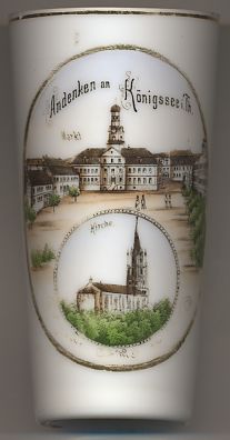 Königsee is situated at an elevation of 419 m in the Rinne valley at the northeastern slopes
of the Thüringer Wald mountains. The municipality has a population of about 5,700 (2003). NB: The glass is wrongly labeled
Königssee although the correct spelling is Königsee.
Königsee is situated at an elevation of 419 m in the Rinne valley at the northeastern slopes
of the Thüringer Wald mountains. The municipality has a population of about 5,700 (2003). NB: The glass is wrongly labeled
Königssee although the correct spelling is Königsee.
The earliest document that mentions Kunegesse dates from 1198. In 1291 it obtained the privilege to mint and issue coins from the counts of Schwarzburg and by 1365 it had obtained the status of a town. As part of the county, 1695 principality, Schwarzburg-Rudolstadt the town in 1668 became the seat of the administration of the district Schwarzburg which soon became known as district Königsee. In 1717 a large fire destroyed almost the whole community and the town had to be rebuilt completely. In the 19th century, Königsee was especially known as a center of shoemaking. In 1899 Königsee was connected to the railroad system. However, the railway line was finally closed in 1966.
The  Town Hall [top picture] was built in 1719–1721.
The town church "Zum Lobe Gottes" (Glorification of the Lord) [bottom picture]
was built in 1871.
Another place with an almost identical name, the lake Königssee (there, an s is used as an interfix to connect the name's two components
'König', 'king', and 'See', 'lake'), is depicted on glass no. 2230 of this collection.
![[scale]](lineal.jpg)