
|
|
| DEUTSCHLAND | GERMANY |
| Bundesland: Freistaat Bayern | Bavaria |
| Regierungsbezirk: Oberfranken | |
| Landkreis: Wunsiedel im Fichtelgebirge |
map →

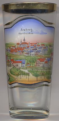 Arzberg is situated at an elevation of 503 m in the valley of the Röslau river at the southeastern slopes of the
Fichtelgebirge mountain region of Upper Franconia, close to the border to the Czech Republic. The municipality has a
population of about 5,100 (2005).
Arzberg is situated at an elevation of 503 m in the valley of the Röslau river at the southeastern slopes of the
Fichtelgebirge mountain region of Upper Franconia, close to the border to the Czech Republic. The municipality has a
population of about 5,100 (2005).
The oldest written mention of Arzperge is found in a document dating from 1268. Already in 1408 it was granted the privileges of a town by the burgraves of Nuremberg. Mining was an important factor for the development of the town. The Prussian naturalist and explorer Alexander von Humboldt, head of the board of mines of the now Prussian principalities of Brandenburg-Ansbach and Brandenburg-Bayreuth, temporarily lived in Arzberg between 1792 and 1796 and founded a mining academy. Together with Ansbach and Payreuth, Arzberg in 1810 became part of Bavaria. Porcellain manufactures opened a new line of industry in 1838. The town charter was renewed in 1876.
The  Protestant church [background centre]
was built in Baroque style in 1790–1792. The church tower was heightened in 1883 and now has a
height of 48 m.
Protestant church [background centre]
was built in Baroque style in 1790–1792. The church tower was heightened in 1883 and now has a
height of 48 m.
Another town of the same name (Arzberg in Styria, Austria) is depicted on another glass in this collection.
![[scale]](lineal.jpg)