
|
|
| DEUTSCHLAND | GERMANY |
| Bundesland: Mecklenburg-Vorpommern | Mecklenburg-West Pomerania |
| Landkreis: Mecklenburgische Seenplatte |
map →
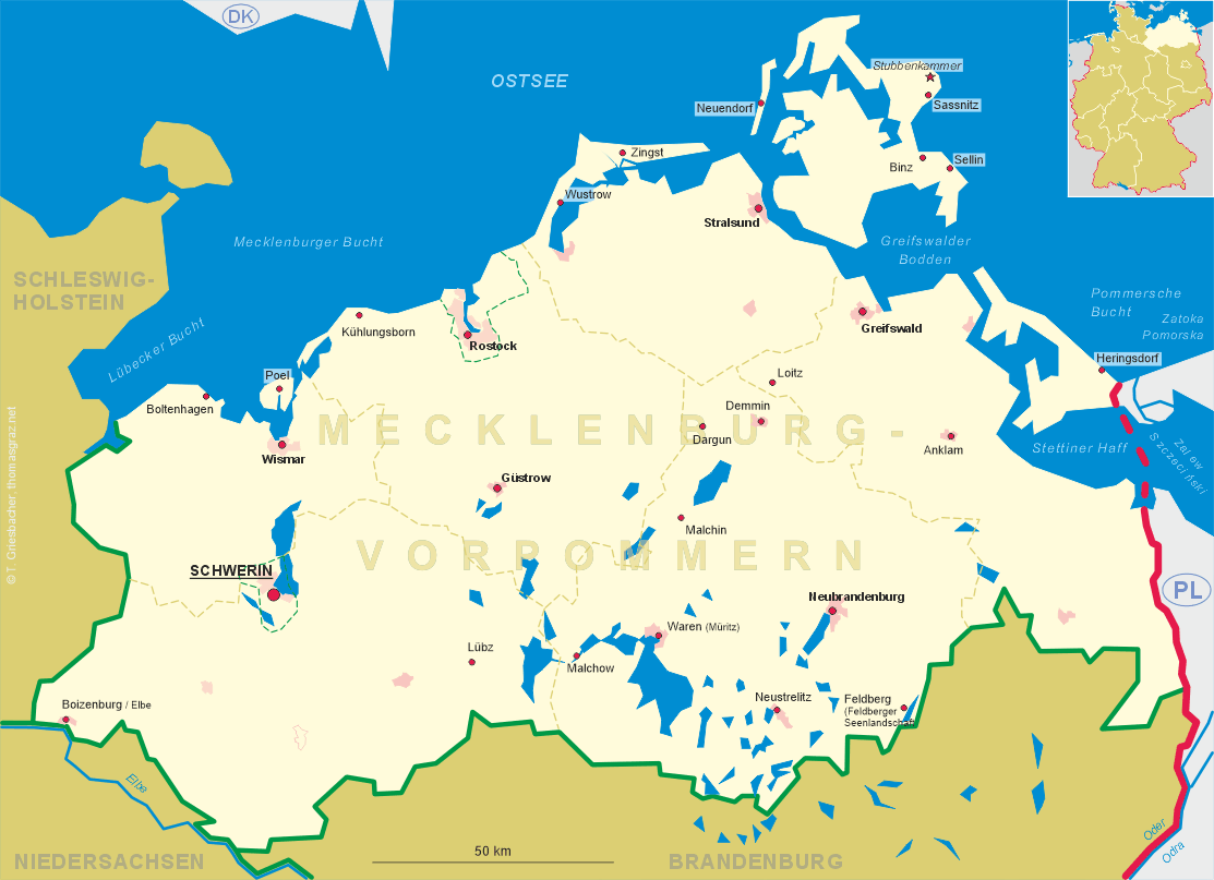
 Malchin is situated at an elevation of 22 m between the lakes Malchiner See and Kummerower See
in the Mecklenburgische Schweiz region of Mecklenburg-Vorpommern.
Malchin is situated at an elevation of 22 m between the lakes Malchiner See and Kummerower See
in the Mecklenburgische Schweiz region of Mecklenburg-Vorpommern.
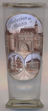
Malchin most likely was founded by Slavic settlers. In 1236 it obtained the privileges of a market town and soon became a prospering trading town as it was located at the crossroads of important trading routes. In 1621, when Mecklenburg was partitioned between Mecklenburg-Schwerin and Mecklenburg-Güstrow, Malchin became one of the two alternating places of assembly of the Mecklenburg estates. Malchin retained this function until the dissolution of the monarchy in 1918. The railroad from Waren to Malchin was opened in 1879. Unfortunately, about two thirds of Malchin's historic old town were destroyed during World War II.
The gateway,  Kalensches Tor [top picture, centre],
was built in the second quarter of the 15th century. The adjacent buildings were destroyed in World War II.
Kalensches Tor [top picture, centre],
was built in the second quarter of the 15th century. The adjacent buildings were destroyed in World War II.
The parish church Sankt Maria und Sankt Johannes [top picture, background right]
was rebuilt in 1397 after a fire had destroyed an earlier church construction.
The Baroque roof of the tower was added in the second half of the 17th century.
The town hall [bottom right picture] dates back to the 14th century.
From that period, the Gothic vaulted basement is still preserved. The major part of the present town hall was
built in 1745. In 1842 the town hall was enlarged in Classicist style. After a fier, the town hall was
rebuilt in 1925–1927.
The soldiers' monument [bottom left picture] was created in 1877 and
was a memorial to the French-German war of 1870/1871.
![[scale]](lineal.jpg)