
|
|
| FRANCE | FRANCE |
| région: Bourgogne-Franche-Comté | |
| département: 25, Doubs |
map →
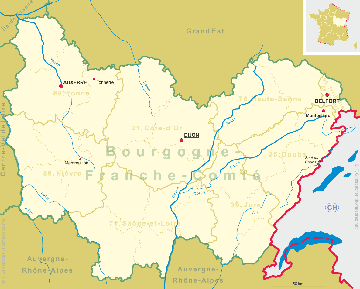
 Montbéliard is situated at an elevation of 317 m in the département Doubs in the région
Bourgogne-Franche-Comté of northeastern France.
Montbéliard is the capital (chef-lieu) of the arrondissement Montbéliard and is also the seat of the administration of
two cantons (Montbéliard-Est, Montbéliard-Ouest). The municipality has a population of about 27,600 (1999).
Montbéliard is situated at an elevation of 317 m in the département Doubs in the région
Bourgogne-Franche-Comté of northeastern France.
Montbéliard is the capital (chef-lieu) of the arrondissement Montbéliard and is also the seat of the administration of
two cantons (Montbéliard-Est, Montbéliard-Ouest). The municipality has a population of about 27,600 (1999).
Mentioned first in 985 as Mons Beliardae, it became a county of the Holy Roman Empire in the 11th century. In 1397 the county, then known as Montfaucon, passed by marriage of Henriette, heiress of the county, to Eberhard IV, Count of Württemberg, to the counts (later dukes) of the House of Württemberg. The German name was first mentioned as Mümppellgart in 1464 (1495 Mümpelgart, 1603 Mömpelgart). In 1524, ten years earlier than in Württemberg, duke Ulrich and reformer Guillaume Farel made Mömpelgard Protestant (specifically Lutheran). From 1598 to 1608, the architect Heinrich Schickhardt built several landmarks of the city, like St. Martin, a castle, a bridge, a college and several hotels. After the French Revolution, it was briefly incorporated into the Rauracian Republic. In 1793 the town was annexed to France, which was confirmed in 1796 and by the Reichsdeputationshauptschluss of 1806. As a consequence of the former rule under the dukes of Württemberg, it has been for centuries one of the few Protestant enclaves in France. [Text adapted from http://en.wikipedia.org/wiki/Montbéliard]
 The
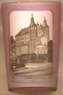
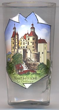
The  château de Montbéliard [left]
is located on an outcropping rock that surveys the town. It is believed that there has been a fortress on the site since the Gallo-Roman times,
though then it was only a wooden watchtower acting as an observation post for the defence of the town of Mandeure (Epomanduodurum).
Until 1397, the castle belonged to the Montfaucon family. The marriage of Henriette d'Orbe to Eberhard IV, son of count Eberhard III of
Württemberg, transferred the ownership of the castle to the Württemberg family. The castle was once divided into two parts around the ancient
Church of Saint-Maimbœuf that dominated the esplanade of the castle with its high belltower. The Châtel-Derrière (rear castle), in the
east, had two imposing towers dating from time immemorial. It contained the reception and the private apartments of the counts and dukes who followed one
another, first in the county and then in the principality. This part of the castle was separated by a wide and deep ditch (which does not exist today),
spanned by a drawbridge. The Châtel-Devant (front castle), in the west, dominates the town of Allan and the river Lizaine (before it channels
underground), and contains along its northern face the single entry of the fortress, together with its drawbridge and portcullis. The drawbridge spanned a
ditch that was added for the protection of the entrance; this ditch was filled in during the great transformations of the 18th century that modified
aspects of the castle. The imposing mass of the Hôtel du Bailli (the bailiff's lodging) always dominated this part of the castle. The castle
was in a state of advanced decay at the end of the 18th century. Several buildings were demolished and rebuilt during the 18th and 19th centuries.
Two prominent 19th-century transformations were the demolition of the Église Saint-Maimbœuf in 1810 and the destruction of the house called
entre les tours (between the towers), which was a building flanked by the Henriette and Frédéric towers characterising
Châtel-Derrière that gives the castle its imposing aspect. This house was replaced by a façade decorated with spires in the Germanic
style of the 17th century.
[Text adapted from http://en.wikipedia.org/wiki/Château_de_Montbéliard]
château de Montbéliard [left]
is located on an outcropping rock that surveys the town. It is believed that there has been a fortress on the site since the Gallo-Roman times,
though then it was only a wooden watchtower acting as an observation post for the defence of the town of Mandeure (Epomanduodurum).
Until 1397, the castle belonged to the Montfaucon family. The marriage of Henriette d'Orbe to Eberhard IV, son of count Eberhard III of
Württemberg, transferred the ownership of the castle to the Württemberg family. The castle was once divided into two parts around the ancient
Church of Saint-Maimbœuf that dominated the esplanade of the castle with its high belltower. The Châtel-Derrière (rear castle), in the
east, had two imposing towers dating from time immemorial. It contained the reception and the private apartments of the counts and dukes who followed one
another, first in the county and then in the principality. This part of the castle was separated by a wide and deep ditch (which does not exist today),
spanned by a drawbridge. The Châtel-Devant (front castle), in the west, dominates the town of Allan and the river Lizaine (before it channels
underground), and contains along its northern face the single entry of the fortress, together with its drawbridge and portcullis. The drawbridge spanned a
ditch that was added for the protection of the entrance; this ditch was filled in during the great transformations of the 18th century that modified
aspects of the castle. The imposing mass of the Hôtel du Bailli (the bailiff's lodging) always dominated this part of the castle. The castle
was in a state of advanced decay at the end of the 18th century. Several buildings were demolished and rebuilt during the 18th and 19th centuries.
Two prominent 19th-century transformations were the demolition of the Église Saint-Maimbœuf in 1810 and the destruction of the house called
entre les tours (between the towers), which was a building flanked by the Henriette and Frédéric towers characterising
Châtel-Derrière that gives the castle its imposing aspect. This house was replaced by a façade decorated with spires in the Germanic
style of the 17th century.
[Text adapted from http://en.wikipedia.org/wiki/Château_de_Montbéliard]
![[scale]](lineal.jpg)