
|
|
| DEUTSCHLAND | GERMANY |
| Bundesland: Baden-Württemberg | |
| Regierungsbezirk: Tübingen | |
| Landkreis: Ravensburg |
map →

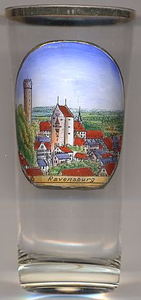 Ravensburg is situated at an elevation of 450 m on the river Schussen in the southern part of the Upper Swabia region.
It is the administrative seat of the district Ravensburg. The municipality has a population of about 49,000 (2008).
Ravensburg is situated at an elevation of 450 m on the river Schussen in the southern part of the Upper Swabia region.
It is the administrative seat of the district Ravensburg. The municipality has a population of about 49,000 (2008).
Ravensburg was first mentioned in writing in 1088. It was founded by the Welfs, a Frankish dynasty in Swabia who became later Dukes of Bavaria and Saxony and who made the castle of Ravensburg their ancestral seat. By a contract of inheritance, in 1191 the Hohenstaufen Frederick Barbarossa acquired the ownership of Ravensburg from Welf VI, Duke of Spoleto and uncle of both Frederick Barbarossa and Henry the Lion. With the death of Konradin 1268 in Naples the Hohenstaufen line became extinct. Their former estates became imperial property of the Holy Roman Empire. Like many other cities in Swabia, at the end of the 13th century Ravensburg became an Imperial Free City in 1276. The "Great Ravensburg Trading Society" (Große Ravensburger Handelsgesellschaft) was founded at Ravensburg and Konstanz around 1380. After the liquidation of the Great Ravensburg Trading Society in 1530, Ravensburg stagnated economically. The Thirty Years' War (1618–1648) caused a grave decline of the population. Following the Reformation a "paritetic" government emerged, meaning an equal distribution of public offices between the Catholic and Protestant confession. The city council was one half each Protestant and Catholic. For some time there was even a Catholic and a Protestant mayor at the same time, and the both confessions celebrated the village fair, the "Rutenfest", apart of each other. This system was approved at the end of the Thirty Years' War in the Peace of Westphalia (1648) which named four "Paritetic Imperial Cities" (German: Paritätische Reichsstädte): Augsburg, Biberach, Dinkelsbühl and Ravensburg. In 1803 the Immerwährende Reichstag passed the Reichsdeputationshauptschluss, a bill which included the secularisation and mediatisation of many German states – the first meaning the confiscation of the estates belonging to the church, the second the incorporation of the imperial estates and Imperial Free Cities into larger regional states. As a result, Ravensburg first became a Bavarian exclave within Württemberg. After a swap of estates between Bavaria and Württemberg it was incorporated in the Kingdom of Württemberg in 1810. Since Ravensburg was impoverished and depopulated after the Thirty Years' War, only a few new buildings were raised during the 18th and the early 19th century. The benefit of this economic stagnation was the conservation of a widely intact medieval city with nearly all towers and gates of the historic fortification. During the World War II Ravensburg was strategically of no relevance. Ravensburg didn't harbour any noteworthy arms industry (unlike the nearby Friedrichshafen with its large aircraft industry), but a big aid supplies center belonging to the Swiss Red Cross. Thus, no air raid destroyed the historical city center. In the 1980s, the Old Town was renovated and all transit traffic was banned from the city center. The Old Town still includes three of the historic town gates and 10 towers of the medieval fortifications. Ravensburg therefore sometimes is called the "Swabian Nuremberg". [Text adapted from http://en.wikipedia.org/wiki/Ravensburg]
The  Mehlsack ('flour sack') [far left] is Ravensburg's popular landmark.
The tower's original name was Weißer Turm bei St. Martin ('White Tower at St. Martin'). It was built in 1425 and is located
at the south-eastern edge of the Old Town. The tower has a height of 51 metres. The names are derived from the twer's white plastering and its characteristic round shape.
[Text adapted from https://de.wikipedia.org/wiki/Mehlsack_(Ravensburg)]
Mehlsack ('flour sack') [far left] is Ravensburg's popular landmark.
The tower's original name was Weißer Turm bei St. Martin ('White Tower at St. Martin'). It was built in 1425 and is located
at the south-eastern edge of the Old Town. The tower has a height of 51 metres. The names are derived from the twer's white plastering and its characteristic round shape.
[Text adapted from https://de.wikipedia.org/wiki/Mehlsack_(Ravensburg)]
The Obertor ('upper gate') [centre] is located at the eastern edge of the Old Town, at its highest elevation.
The gate was built in 1346–1355 and was modified in the 15th and the early 16th century.
![[scale]](lineal.jpg)