
|
|
| DEUTSCHLAND | GERMANY |
| Bundesland: Freistaat Sachsen | Saxony |
| Landkreis: Erzgebirgskreis |
map →

 Auerbach / Vogtl. is situated at an elevation of 555 m in the Göltzsch valley. Auerbach has a population of about 20,000 (2009)
and thus is the third-largest town of the Vogtland district after Plauen and Reichenbach im Vogtland.
Auerbach / Vogtl. is situated at an elevation of 555 m in the Göltzsch valley. Auerbach has a population of about 20,000 (2009)
and thus is the third-largest town of the Vogtland district after Plauen and Reichenbach im Vogtland.
The oldest written document mentioning Urbach dates from 1282. Around 1400 it was awarded an own crest by the bayliffs of Plauen, Greiz, Weida und Gera. In 1505 Auerbach became the seat of a board of mines and in 1543 obtained the status of a mining town. From 1874 until 1995 Auerbach was the seat of the administration of the district Auerbach which on 1 January 1996 was merged with the districts Klingenthal, Oelsnitz, Reichenbach and Plauen to become the new district Vogtlandkreis.
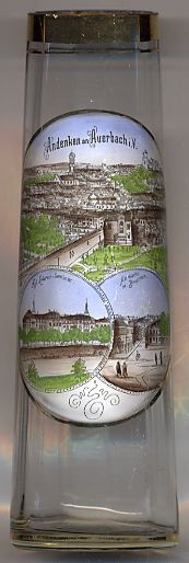
The picture on glass no. 2617 shows a panoramic view of Auerbach.
The bottom left picture shows the  Royal
Royal
The bottom right picture shows the Altmarkt.
![[scale]](lineal.jpg)