
|
|
| UNITED STATES OF AMERICA | |
| MICHIGAN | |
| Mackinac County |
map →
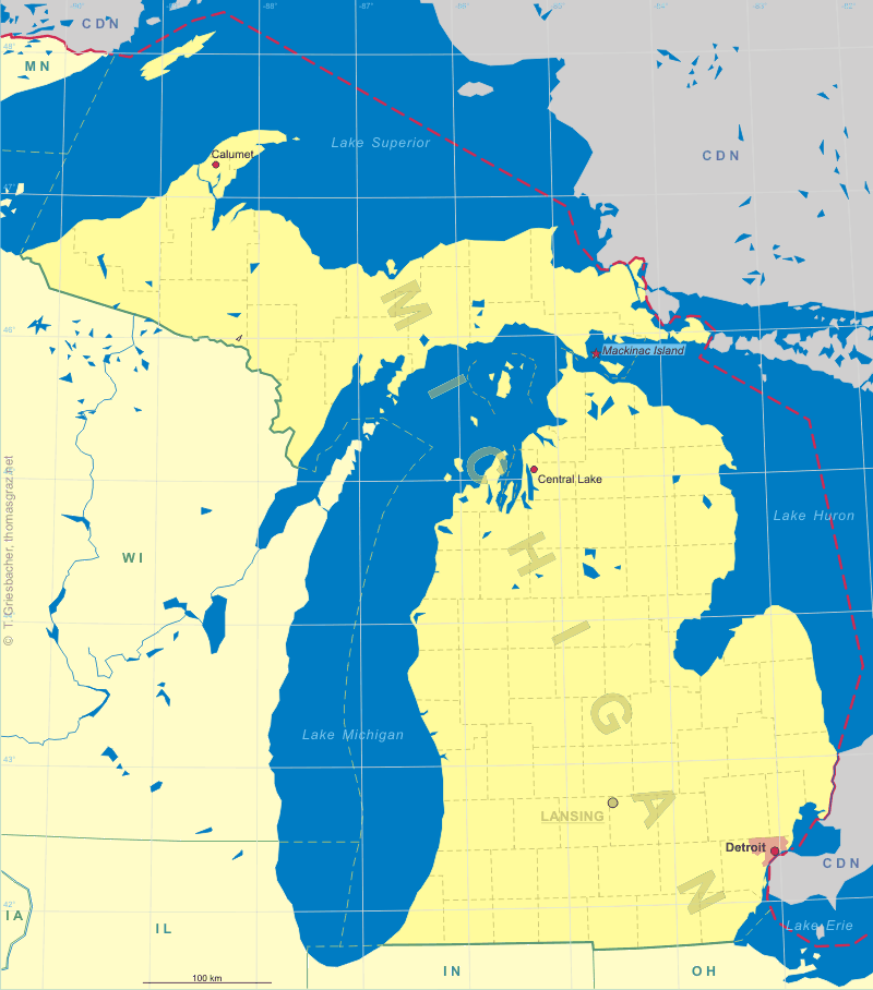
 Mackinac Island is an island covering 3.8 square miles (9.8 km²) in land area, part of the U.S. state of Michigan. It is located in Lake Huron,
at the eastern end of the Straits of Mackinac, between the state's Upper and Lower Peninsulas. The island was home to a Native American settlement before
European exploration began in the 17th century. It served a strategic position amidst the commerce of the Great Lakes fur trade. This led to the establishment
of Fort Mackinac on the island by the British during the American Revolutionary War. It was the scene of two battles during the War of 1812. In the late 19th
century, Mackinac Island became a popular tourist attraction and summer colony. Much of the island has undergone extensive historical preservation and restoration;
as a result, the entire island is listed as a National Historic Landmark. More than 80 percent of the island is preserved as Mackinac Island State Park.
[Text adapted from http://en.wikipedia.org/wiki/Mackinac_Island]
Mackinac Island is an island covering 3.8 square miles (9.8 km²) in land area, part of the U.S. state of Michigan. It is located in Lake Huron,
at the eastern end of the Straits of Mackinac, between the state's Upper and Lower Peninsulas. The island was home to a Native American settlement before
European exploration began in the 17th century. It served a strategic position amidst the commerce of the Great Lakes fur trade. This led to the establishment
of Fort Mackinac on the island by the British during the American Revolutionary War. It was the scene of two battles during the War of 1812. In the late 19th
century, Mackinac Island became a popular tourist attraction and summer colony. Much of the island has undergone extensive historical preservation and restoration;
as a result, the entire island is listed as a National Historic Landmark. More than 80 percent of the island is preserved as Mackinac Island State Park.
[Text adapted from http://en.wikipedia.org/wiki/Mackinac_Island]
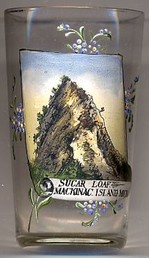
 Sugar Loaf [left]
is a 75-foot-high (23 m) landlocked rock or stack in the interior of Mackinac Island in Lake Huron. Created by erosion during the period of postglacial Lake Algonquin,
Sugar Loaf is the largest post-glacial erosion feature in the Straits of Mackinac. The immense rock, which consists of resistant limestone breccia, was cut off from
Ancient Mackinac Island or the 'Turtle's Back' by the glacial meltwaters of Lake Algonquin. Polar storms released by the retreating ice sheet created erosional forces
much stronger than any existing today on the Great Lakes. The rock lies within the boundaries of the Mackinac Island State Park near the junction of Crooked Tree Road
and Sugar Loaf Road.
[Text adapted from http://en.wikipedia.org/wiki/Sugar_Loaf_(Mackinac_Island)]
Sugar Loaf [left]
is a 75-foot-high (23 m) landlocked rock or stack in the interior of Mackinac Island in Lake Huron. Created by erosion during the period of postglacial Lake Algonquin,
Sugar Loaf is the largest post-glacial erosion feature in the Straits of Mackinac. The immense rock, which consists of resistant limestone breccia, was cut off from
Ancient Mackinac Island or the 'Turtle's Back' by the glacial meltwaters of Lake Algonquin. Polar storms released by the retreating ice sheet created erosional forces
much stronger than any existing today on the Great Lakes. The rock lies within the boundaries of the Mackinac Island State Park near the junction of Crooked Tree Road
and Sugar Loaf Road.
[Text adapted from http://en.wikipedia.org/wiki/Sugar_Loaf_(Mackinac_Island)]
![[scale]](lineal.jpg)