
|
|
| DEUTSCHLAND | GERMANY |
| Bundesland: Brandenburg | |
| Stadt: Cottbus |
map →
Cottbus is situated at an elevation of 70 m on the river Spree in southern Brandenburg. With a population of about 101,700 (2009), Cottbus is the second-largest city of the state after its capital, Potsdam. Cottbus is administered as a district in its own right, but is also the administrative seat of the district Spree-Neiße.
 The settlement was established in the 10th century, when Sorbs erected a castle on a sandy island in the River Spree. The first recorded mention of the town's name was in 1156.
In the 13th century German settlers came to the town and thereafter lived side-by-side with the Sorbs. In medieval times Cottbus was known for wool, and the town's drapery
was exported all over to Brandenburg, Bohemia and Saxony. In 1462 Cottbus was acquired by the Margraviate of Brandenburg; in 1701 the city became part of the Kingdom of Prussia.
In 1815 the surrounding districts of Upper and Lower Lusatia were ceded by the Kingdom of Saxony to Prussia.
The settlement was established in the 10th century, when Sorbs erected a castle on a sandy island in the River Spree. The first recorded mention of the town's name was in 1156.
In the 13th century German settlers came to the town and thereafter lived side-by-side with the Sorbs. In medieval times Cottbus was known for wool, and the town's drapery
was exported all over to Brandenburg, Bohemia and Saxony. In 1462 Cottbus was acquired by the Margraviate of Brandenburg; in 1701 the city became part of the Kingdom of Prussia.
In 1815 the surrounding districts of Upper and Lower Lusatia were ceded by the Kingdom of Saxony to Prussia.
[Text adapted from http://en.wikipedia.org/wiki/Cottbus]
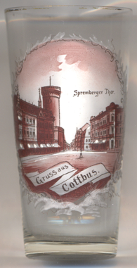
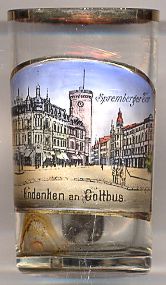
The  Spremberger Turm ('Spremberg Tower')
[left, no. 3823; right: no. 2624, and below, no. 3241: background]
is the landmark of Cottbus. The tower goes back to a gate tower of the 13th/14th century. When Cottbus had withstood the assaults of the Hussites in 1429,
the town's fortifications were reinforced. In 1773/1774 the tower received a new domed roof, a clock and two bells. Nevertheless, large parts of the tower
were dismantled in 1810/1811. The tower was then rebuilt in 1824/1825 following plans by the architect Karl Friedrich Schinkel. In 1847 the gate itself received a
passage for pedestrians, but in 1875 the gate was demolished. The bastion next to the tower was demolished in 1878/1879 after the structure had been documented photographically.
The tower received a new clock in 1970. Since 2007 the tower is again open to the public. The tower has a total height of 31 metres.
Spremberger Turm ('Spremberg Tower')
[left, no. 3823; right: no. 2624, and below, no. 3241: background]
is the landmark of Cottbus. The tower goes back to a gate tower of the 13th/14th century. When Cottbus had withstood the assaults of the Hussites in 1429,
the town's fortifications were reinforced. In 1773/1774 the tower received a new domed roof, a clock and two bells. Nevertheless, large parts of the tower
were dismantled in 1810/1811. The tower was then rebuilt in 1824/1825 following plans by the architect Karl Friedrich Schinkel. In 1847 the gate itself received a
passage for pedestrians, but in 1875 the gate was demolished. The bastion next to the tower was demolished in 1878/1879 after the structure had been documented photographically.
The tower received a new clock in 1970. Since 2007 the tower is again open to the public. The tower has a total height of 31 metres.
[https://de.wikipedia.org/wiki/Spremberger_Turm]
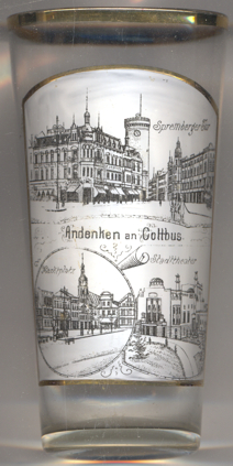
The bottom left picture on glass no. 3241 [near left] shows a view of the square,
Altmarkt
[https://de.wikipedia.org/wiki/Altmarkt_(Cottbus)]
The Oberkirche Sankt Nikolai [background] was first mentioned in 1156.
The present church was built between the 2nd half of the 15th century until the 16th century. Renvated in 1910/1911,
the church was devastated by a large fire during World War II in 1945. Further parts of the church collapsed in
1946. The church was then rebuilt until 1960/1965.
[https://de.wikipedia.org/wiki/Oberkirche_St._Nikolai]
The Staatstheater Cottbus [bottom right picture]
was built in 1907–1908 as Stadttheater (Municipal theatre) in Secessionist Art Nouveau style by the
architect Bernhard Sehring.
During World War II it was used as an ammunition depot. After the war, plans for demolishing the theatre
were abandoned after protests from the citizens of Cottbus. A functional tract was added in 1910–1912.
After major renovations beginnning in 1982, the theatre was reopened in 1986.
Since 1992, the theatre is owned by the state of Brandenburg; it is the state's only state-owned theatre (Staatstheater).
Today, it is used for theatre, musical theatre, ballet and orchestra performances. the theatre has a capacity of
about 680 seats.
[https://de.wikipedia.org/wiki/Staatstheater_Cottbus, http://www.andreas-praefcke.de/carthalia/]
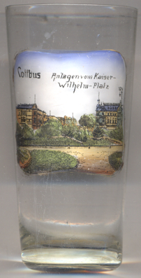
The park in Kaiser-Wilhelm-Platz [near left, no. 3242] was laid out in
1904–1904. Originally named Neustädter Platz ('New Town Square'), the square was renamed in 1888 in honour
of Emperor Wilhelm I who had died in that year. In 1946, it was renamed Thälmannplatz for Ernst Thählmann,
chairmann of the German Communist Party 1925–1933. Today, the square bears the name Brandenburger Platz.
[http://maerkischer-bote.de/blog/2008/02/02/cottbus-der-brandenburger-platz-von-1916/,
http://maerkischer-bote.de/blog/2012/01/21/cottbus-das-bild-vom-kaiser-wilhelm-platz-entstand-kurz-vor-dem-i-weltkrieg/]
![[scale]](lineal.jpg)