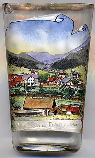

|
| ÖSTERREICH | AUSTRIA |
| Bundesland: Steiermark | Styria |
| Bezirk: Bruck-Mürzzuschlag |
 Frein an der Mürz is situated at an elevation of 936 m on the headwaters of the river Mürz in the district Bruck-Mürzzuschlag in northeastern Styria.
Frein is a cadastral community of the municipality of Mürzsteg and has a population of about 65 (2001).
The oldest written document mentioning Frein dates from 1780. In 1892 Frein became an independent parish.
In 1948 Frein (except Krampen) was separated from the municipality of Halltal and was merged with Mürzsteg while Krampen was merged
into the municipality of Neuberg an der Mürz.
![[scale]](lineal.jpg)