
|
|
| ÖSTERREICH | AUSTRIA |
| Bundesland: Steiermark | Styria |
| Bezirk: Bruck-Mürzzuschlag |
map →

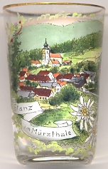 Stanz im Mürztal is situated at an elevation of 669 m in the valley of the Stanzbach stream, a tributary of the river Mürz,
in the district Bruck-Mürzzuschlag in northeastern Styria.
The municipality has a population of about 1,900 (2012).
Stanz im Mürztal is situated at an elevation of 669 m in the valley of the Stanzbach stream, a tributary of the river Mürz,
in the district Bruck-Mürzzuschlag in northeastern Styria.
The municipality has a population of about 1,900 (2012).
The earliest mention of Stawencz in a written document dates from 1150. In the 14h century Stanz came in possession of the lords of Stubenberg. Around 1836 Stanz was an important place of hammer mills. The municipality of Stanz was founded in 1850.
The  Catholic parish church Sankt Katharina [background]
was built between 1232 and 1359. The present church was completed in 1741.
Catholic parish church Sankt Katharina [background]
was built between 1232 and 1359. The present church was completed in 1741.
[https://de.wikipedia.org/wiki/Stanz_im_Mürztal, https://de.wikipedia.org/wiki/Liste_der_denkmalgeschützten_Objekte_in_Stanz_im_Mürztal]
![[scale]](lineal.jpg)