
|
|
| POLSKA | POLAND |
| województwo: Zachodniopomorskie | voivodship: West Pomerania |
| powiat: Gryfice | county: Gryfice |
map →
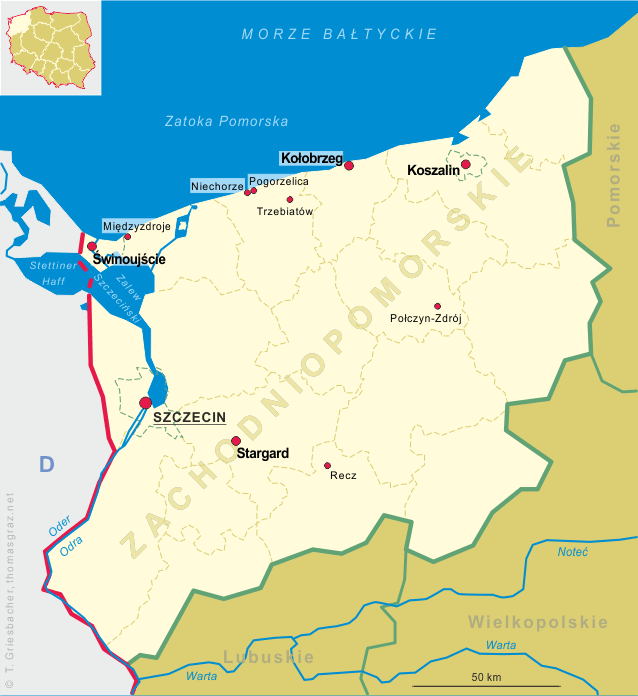
Trzebiatow (German: Treptow an der Rega) is situated at an elevation of 8 m at the river Rega in the West Pomeranian voivodship of northern Poland, about 11 km from the river's mouth into the Baltic Sea. Trzebiatów proper has a population of about 10,250 (2012), the urban-rural municipality (gmina miejsko-wiejska), which includes further 21 villages, has a total population of about 16,000.
 The lower Rega area around Greifenberg (Gryfice) and Treptow (Trzebiatów) was settled by immigrants of German language in the 1250s, and settling reached a peak in the 1280s, but here
a native Slavic population participated. At this time Treptow was part of the Duchy of Pomerania, which was a component state within the Holy Roman Empire since 1180. On 13 December,
1534, a Landtag (diet) was assembled in town, where the Dukes Barnim XI of Pomerania-Stettin and Philip I of Pomerania-Wolgast as well as the nobility
officially introduced Lutheranism to Pomerania, against the vote of the Prince-Bishop of Cammin (Kamień Pomorski). In the following month the new church order (Kirchenordnung) was
drafted, founding the Pomeranian Lutheran church, today's Pomeranian Evangelical Church.
When in 1637 with Duke Philip II's death the Pomeranian ducal house was extinct, the duchy was under Swedish occupation with the Brandenburgian electors claiming succession in
Pomerania. Not until 1648 the electors prevailed in succeeding as dukes of Pomerania, however, only in the central and eastern part of ducal Pomerania (1653–1815),
With the end of the Holy Roman Empire in 1806, Brandenburg-Pomerania, already since 1618 ruled in personal union with Ducal Prussia (Kingdom since 1701), also legally merged into Prussia.
In 1945 central and eastern Pomerania, including Treptow, became part of Poland.
The lower Rega area around Greifenberg (Gryfice) and Treptow (Trzebiatów) was settled by immigrants of German language in the 1250s, and settling reached a peak in the 1280s, but here
a native Slavic population participated. At this time Treptow was part of the Duchy of Pomerania, which was a component state within the Holy Roman Empire since 1180. On 13 December,
1534, a Landtag (diet) was assembled in town, where the Dukes Barnim XI of Pomerania-Stettin and Philip I of Pomerania-Wolgast as well as the nobility
officially introduced Lutheranism to Pomerania, against the vote of the Prince-Bishop of Cammin (Kamień Pomorski). In the following month the new church order (Kirchenordnung) was
drafted, founding the Pomeranian Lutheran church, today's Pomeranian Evangelical Church.
When in 1637 with Duke Philip II's death the Pomeranian ducal house was extinct, the duchy was under Swedish occupation with the Brandenburgian electors claiming succession in
Pomerania. Not until 1648 the electors prevailed in succeeding as dukes of Pomerania, however, only in the central and eastern part of ducal Pomerania (1653–1815),
With the end of the Holy Roman Empire in 1806, Brandenburg-Pomerania, already since 1618 ruled in personal union with Ducal Prussia (Kingdom since 1701), also legally merged into Prussia.
In 1945 central and eastern Pomerania, including Treptow, became part of Poland.
[https://de.wikipedia.org/wiki/Trzebiatów, http://en.wikipedia.org/wiki/Trzebiatów]
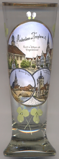
The  Town Hall [top picture: left] in the centre of the market square was built in 1701 in Baroque style.
The building was renovated in 1901. Three arcades from the prior town hall from the 15th century are preserved on the side of the building.
Town Hall [top picture: left] in the centre of the market square was built in 1701 in Baroque style.
The building was renovated in 1901. Three arcades from the prior town hall from the 15th century are preserved on the side of the building.
[http://www.bildindex.de, http://www.polnischeostseekueste.de/ausflugstipps/treptow-an-der-rega/das-rathaus-von-treptow-an-der-rega/]
The soldiers' monument [top picture: left foreground] next to the town hall commemorated the German soldiers killed in the
Franco-Prussian War War of 1870/1871.
[http://www.bildindex.de]
The Catholic parish church of Our Lady's Motherhood (Kościół Macierzyństwa Najświętszej Marii Panny)
[bottom left picture: background] was built in 1303–1370 in Brick Gothic style.
The church tower was rebuilt in 1864 by Friedrich August Stüler; the tower
has a height of 90 metres.
[https://de.wikipedia.org/wiki/Trzebiatów]
The Sergeant School [bottom right picture] in Treptow was founded in 1901.
The picture on glass no. 2834 shows the main guard-house (Hauptwache).
[http://www.lexikon-der-wehrmacht.de/Soldat/Uneroffiziersschule-R.htm]
![[scale]](lineal.jpg)