
|
|
| FRANCE | FRANCE |
| région: Occitanie | |
| département: 65, Hautes-Pyrénées |
map →
Cauterets is situated at an elevation of 1,296 m in the French Pyrenees, about 32 km southwest of
Lourdes in the valley of the Gave de Cauterets, bordering the Pyrenees National Park.
The municiplity has a population of about 1,140 (2010).
The
The
 Cauterets is well known for its copious thermal springs. They are chiefly characterized by the presence of sulphur and silicate of soda, and are used in the treatment of diseases
of the respiratory organs, rheumatism, skin diseases and many other maladies. The main thermal baths, Thermes Cesar, were opened in 1843 and continue to offer treatments today.
Cauterets is well known for its copious thermal springs. They are chiefly characterized by the presence of sulphur and silicate of soda, and are used in the treatment of diseases
of the respiratory organs, rheumatism, skin diseases and many other maladies. The main thermal baths, Thermes Cesar, were opened in 1843 and continue to offer treatments today.
[https://de.wikipedia.org/wiki/Cauterets, https://en.wikipedia.org/wiki/Cauterets]
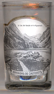
 Lac de Gaube [left, no. 2870: foreground] is situated in an elevation of 1,725 m, an egg-shaped form stretching itself along a north-south axis
in the Gaube valley (valée de Gaube). The name actually is a pleonasm as Gaube means 'lake' in the Gascon dialect. Its principal inflows are the Gaube River tributaries
(Gave des oulettes de Gaube), which take their name from the Gaube River, which is the principal outflow of the lake. The lake has an average depth of 40 m, surface area of
19 hectares, and more than 2 km of shoreline. A delta situated at the mouth of the principal outflow of the lake is loaded with glacial alluvial deposits.
Lac de Gaube [left, no. 2870: foreground] is situated in an elevation of 1,725 m, an egg-shaped form stretching itself along a north-south axis
in the Gaube valley (valée de Gaube). The name actually is a pleonasm as Gaube means 'lake' in the Gascon dialect. Its principal inflows are the Gaube River tributaries
(Gave des oulettes de Gaube), which take their name from the Gaube River, which is the principal outflow of the lake. The lake has an average depth of 40 m, surface area of
19 hectares, and more than 2 km of shoreline. A delta situated at the mouth of the principal outflow of the lake is loaded with glacial alluvial deposits.
[https://en.wikipedia.org/wiki/Lac_de_Gaube, https://fr.wikipedia.org/wiki/Lac_de_Gaube]
Vignemale [background] is a mountain massiv of the Pyrenees that straddles into Spain. Its principal summits are
Grand Vignemale or Pique-Longue (3,298 m, the highest elevation of the French Pyrenees), Pointe Chausenque (3,204 m) and Petit Vignemale (3,032 m).
The Vignemale is also the site of the second largest of the Pyrenean glaciers (after the one of Pic Aneto in Spain, the highest mountain of the entire Pyrenees), the Ossoue
(with around 0.6 km²), across which is the "voie normale" or standard route to the summit.
[https://en.wikipedia.org/wiki/Vignemale]
![[scale]](lineal.jpg) contact: webmaster
contact: webmaster