
|
|
| DEUTSCHLAND | GERMANY |
| Bundesland: Baden-Württemberg | |
| Regierungsbezirk: Tübingen | |
| Landkreis: Alb-Donau-Kreis |
map →

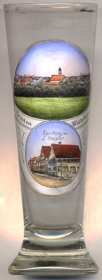 Westerheim is located in the Schwäbische Alb (Swabian Jura) region of Baden-Württemberg about 30 km northwest of Ulm.
An elevation of 815 m it is the highest municipality of the Donau-Alb district. The municipality has a population
of about 2,900 (2012).
Westerheim is located in the Schwäbische Alb (Swabian Jura) region of Baden-Württemberg about 30 km northwest of Ulm.
An elevation of 815 m it is the highest municipality of the Donau-Alb district. The municipality has a population
of about 2,900 (2012).
The oldest written document mentioning Westerheim is the deed of foundation of the monastery of Wiesensteig dating from 861 AD. In 1309 Westerheim came in possession of the counts of Helfenstein who in 1555 introduced the Reformation; however, only twelve years later, in 1567, the town returned to the Catholic faith. In 1642 the town became part of Bavaria. Since 1806 it was art of the kingdom of Württemberg. In 1986 Westerheim was officially recognised as a climatic spa.
The  church of St. Stephanus [top] was built in 1787/88 in place of an older church of the 14th century.
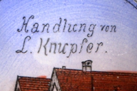 The building depicted on the bottom picture on glass no. 2978 is labeled as Handlung von L. Knupfer ('store of L.K.').
[https://de.wikipedia.org/wiki/Westerheim_(Württemberg), http://www.westerheim.de/servlet/PB/menu/1360070_l1/index.html]
![[scale]](lineal.jpg)