
|
|
| DEUTSCHLAND | GERMANY |
| Bundesland: Baden-Württemberg | |
| Regierungsbezirk: Tübingen | |
| Landkreis: Alb-Donau-Kreis |
map →

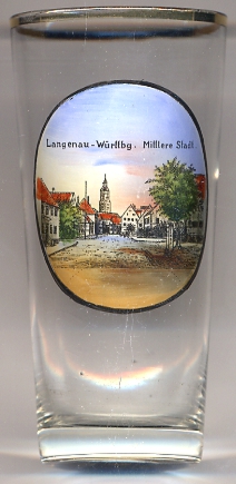 Langenau is situated at an elevation of 463 m on the river Nauin the northeast of the district Alb-Donau-Kreis, about 16 km northeast of
the district's capital, Ulm (which itself is independent of the district). Langenau has a population of about
14,200 (2012) and thus is the district's second largest town after Ehingen.
Langenau is situated at an elevation of 463 m on the river Nauin the northeast of the district Alb-Donau-Kreis, about 16 km northeast of
the district's capital, Ulm (which itself is independent of the district). Langenau has a population of about
14,200 (2012) and thus is the district's second largest town after Ehingen.
Langenau's name is derived from the river Nau and was first mentioned as Nawe or Navua in 1003. The village was chartered as a town in 1301; however, it lost these privilages in 1377. The name Langenau came in use in 1531; thereafter, it usually was divided into the 'upper', 'middle' and 'lower' village. Langenau was chartered agin as a town in 1848. In 1972 the neighbouring communities of Albeck, Hörvelsingen and Göttingen were incorporated into the municipality of Langenau. In 1973 Langenau became part of the district Alb-Dnau-Kreis and thus the administrative region Tübingen (before that the district was part of the administrative region Stuttgart).
The Protestant  Martinskirche [background centre]
dates from the 14th to 18th century. It was built in place of an old Roman temple. The original church was completed in 1441.
The nave was rebuilt in 1669. The church tower was built in the years after 1468; the octogonal upper part with its domed roof
dates from the Baroque period.
Martinskirche [background centre]
dates from the 14th to 18th century. It was built in place of an old Roman temple. The original church was completed in 1441.
The nave was rebuilt in 1669. The church tower was built in the years after 1468; the octogonal upper part with its domed roof
dates from the Baroque period.
[https://de.wikipedia.org/wiki/Langenau; http://www.langenau.de/de/01_stadt/01.05_geschichte/c_main.php;
http://www.bidindex.de]
![[scale]](lineal.jpg)