
|
|
| ČESKÁ REPUBLIKA | CZECH REPUBLIC |
| Plzeňský kraj | Plzeň region |
| Okres: Domažlice |
map →
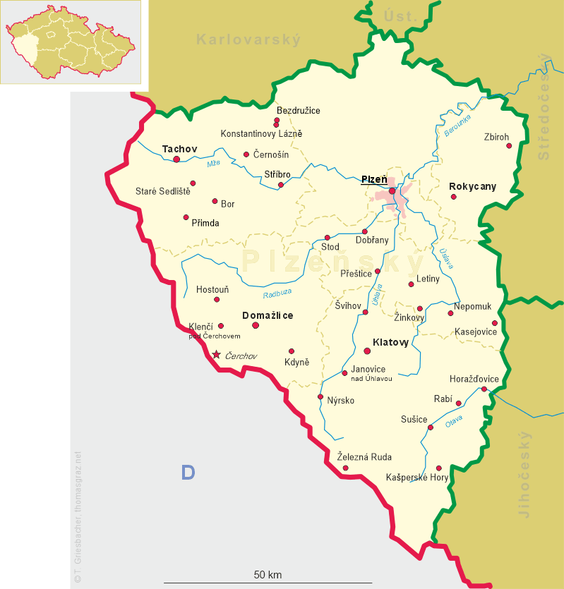
 Kdyně is situated at an elevation of 455 m in the Plzeň region,
district Domažlice in western Bohemia.
Kdyně is a ‘municipality with commissioned local authority’ (‘obec s pověřeným obecním úřadem’) within the
Domažlice ‘municipality with extended competence’ (‘obec s rozšířenou působností’).
Kdyně has a population of about 5,300 (2015).
Kdyně is situated at an elevation of 455 m in the Plzeň region,
district Domažlice in western Bohemia.
Kdyně is a ‘municipality with commissioned local authority’ (‘obec s pověřeným obecním úřadem’) within the
Domažlice ‘municipality with extended competence’ (‘obec s rozšířenou působností’).
Kdyně has a population of about 5,300 (2015).
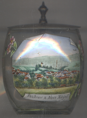
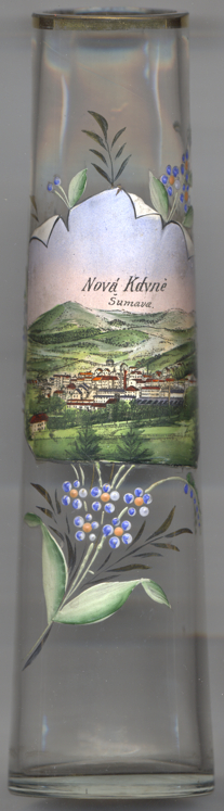
 A document of 1384 already mentions a settlement in this area, which obtained the status of a market in 1508 town; however,
this was a separate settlement which was destroyed by a large fire in the mid-16th century and later was refered to as
Stará Kdyně (in German: Altgedein). The present town (in German: Neugedein) was first mentioned in 1586
and at that time belonged to the lords of Riesenberg (in Czech: Rýzmberk). In 1697 the ownership passed to the counts Stadion.
Kdyně wss chartered as a town in 1840.
The first textile manufacture of Bohemia was founded here in 1678 and since then, the town was a textile industry centre.
The town was the seat of a district court between 1850 and 1949, between 1855 and 1868 also of district authorities.
A document of 1384 already mentions a settlement in this area, which obtained the status of a market in 1508 town; however,
this was a separate settlement which was destroyed by a large fire in the mid-16th century and later was refered to as
Stará Kdyně (in German: Altgedein). The present town (in German: Neugedein) was first mentioned in 1586
and at that time belonged to the lords of Riesenberg (in Czech: Rýzmberk). In 1697 the ownership passed to the counts Stadion.
Kdyně wss chartered as a town in 1840.
The first textile manufacture of Bohemia was founded here in 1678 and since then, the town was a textile industry centre.
The town was the seat of a district court between 1850 and 1949, between 1855 and 1868 also of district authorities.
Mount  Koráb [right, no. 3439: background right] (773 m)
is situated about 3 km east of Kdyně and is part of a range of low mountains to the north and east of the
town. Just southeast of it, the Špandava reaches a height of 774 m. Because of the exceptional view, the
Czechoslovak Tourist Club KČT already in 1902 made plans for a lookout tower, which, however, only were realised
in 1936. The wooden construction (21 m high) was inaugurated in 1938. In 1948, the stairscase was encased in a wooden
boarding to protect it from bad weather. Nevertheless, by the mid 1980s its condition had deteriorated so much that it
had to be demolished. A new iron construction (total height 50 m) with a lookout platform at a height of 30 metres
was built in 1992. Herštejn castle (see below) and Příkopy castle are situated to the northwest.
Koráb [right, no. 3439: background right] (773 m)
is situated about 3 km east of Kdyně and is part of a range of low mountains to the north and east of the
town. Just southeast of it, the Špandava reaches a height of 774 m. Because of the exceptional view, the
Czechoslovak Tourist Club KČT already in 1902 made plans for a lookout tower, which, however, only were realised
in 1936. The wooden construction (21 m high) was inaugurated in 1938. In 1948, the stairscase was encased in a wooden
boarding to protect it from bad weather. Nevertheless, by the mid 1980s its condition had deteriorated so much that it
had to be demolished. A new iron construction (total height 50 m) with a lookout platform at a height of 30 metres
was built in 1992. Herštejn castle (see below) and Příkopy castle are situated to the northwest.

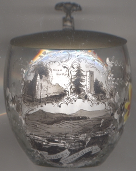 Nový Herštejn castle [left, no. 4867, and right, no. 3213: top left picture]
(previously in Czech: Herštýn, German: Neu Hirschstein, previously Herrnstein)
is located on the Herštýn (elevation 681 m), about about 5 km northeast of Kdyně, in the
municipality of Němčice. It was built in the second half of the 13th century. In 1475, the castle was besieged
and heavily damaged by Bavarian troops. The ruins were purchased shortly after that by the lords of Riesenberg
(Rýzmberk) but they were never restored.
Nový Herštejn castle [left, no. 4867, and right, no. 3213: top left picture]
(previously in Czech: Herštýn, German: Neu Hirschstein, previously Herrnstein)
is located on the Herštýn (elevation 681 m), about about 5 km northeast of Kdyně, in the
municipality of Němčice. It was built in the second half of the 13th century. In 1475, the castle was besieged
and heavily damaged by Bavarian troops. The ruins were purchased shortly after that by the lords of Riesenberg
(Rýzmberk) but they were never restored.
Ryzmberk castle [left, no. 4867, and right, no. 3213: top right picture]
(German: Burg Riesenberg) near Kdyně was built in the second half of the 13th century in order to guard a pass
on the main route connecting Prague and Passau. The castle was rebuilt
and enlarged several times during the ensuing centuries and was one of the most fortified castles in Bohemia. However,
during the Thirty Years' War (1618–1648) it was conquered by Imperial troops in 1620, conquered and looted by
Swedish troops in 1641. Emperor Ferdinand III finally ordered the destruction of its fortifications in 1655. Since
1697 a property of the counts Stadion, the ruins only were used as a park. A lookout tower was built in 1846–1847.
In 1935, an open-air stage was created, which currently serves as home of the country and folklore festival
Rýzmberský hradní guláž. The castle also is mentioned in George Sand's book
Consuelo.
[https://de.wikipedia.org/wiki/Kdyně, https://en.wikipedia.org/wiki/Kdyně;
, https://de.wikipedia.org/wiki/Burg_Rýzmberk]
![[scale]](lineal.jpg)