
|
|
| DEUTSCHLAND | GERMANY |
| Bundesland: Freistaat Sachsen | Saxony |
| Landkreis: Bautzen |
map →

 Radeberg is situated at an elevation of 250 m at the edge of the Fresdner Heide region, just northwest
of Saxony's capital, Dresden. The municipality has a population of about 18,400 (2015)
and consists of Radeberg proper, Liegau-Augustusbad, Großerkmannsdorf and Ullersdorf.
Radeberg is situated at an elevation of 250 m at the edge of the Fresdner Heide region, just northwest
of Saxony's capital, Dresden. The municipality has a population of about 18,400 (2015)
and consists of Radeberg proper, Liegau-Augustusbad, Großerkmannsdorf and Ullersdorf.
Radeberg was first mentioned in a document dating from 1219. In 1412 it was chartered as a town. In the 19th century, especially after the completion in 1845 of the railroad from Dresden to Görlitz, it became an important industry site. The neighbouring municipality of Liegau-Augustusbad was incorporated into Radeberg in 1995, followed by Großerkmannsdorf and Ullersdorf in 1999. In 2009 Radeberg obtained the status of 'Große Kreisstadt' (large district town).
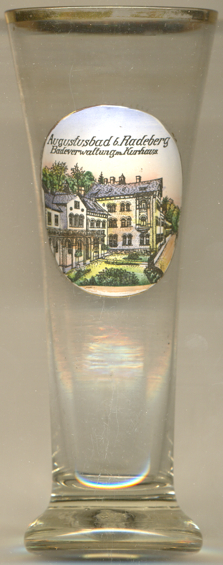
The mineral spring of  Augustusbad [left] was discovered in 1717.
The first spa was opened in 1719 and was originally named Bad im Tannengrunde but was soon renamed
Radeberger Bad. Since even Elector Friedrich August I (King August II of Poland, 'August the Strong')
regularly enjoyed the waters, the spa as renamed in his honour Augustusbrunnen or Augustusbad in 1724.
All three names remained equally in use up until the 19th century; it was only in the 2nd half of the century, that
only the name Augustusbad became official. In 1922, the municipality of Liegau was renamed Liegau-Augustusbad
which in 1995 became part of the municipality of Radeberg.
Augustusbad [left] was discovered in 1717.
The first spa was opened in 1719 and was originally named Bad im Tannengrunde but was soon renamed
Radeberger Bad. Since even Elector Friedrich August I (King August II of Poland, 'August the Strong')
regularly enjoyed the waters, the spa as renamed in his honour Augustusbrunnen or Augustusbad in 1724.
All three names remained equally in use up until the 19th century; it was only in the 2nd half of the century, that
only the name Augustusbad became official. In 1922, the municipality of Liegau was renamed Liegau-Augustusbad
which in 1995 became part of the municipality of Radeberg.
[https://de.wikipedia.org/wiki/Radeberg, https://de.wikipedia.org/wiki/Augustusbad]
![[scale]](lineal.jpg)