
|
|
| DEUTSCHLAND | GERMANY |
| Bundesland: Nordrhein-Westfalen | North Rhine-Westphalia |
| Regierungsbezirk: Düsseldorf | |
| Stadt: Mülheim an der Ruhr |
map →
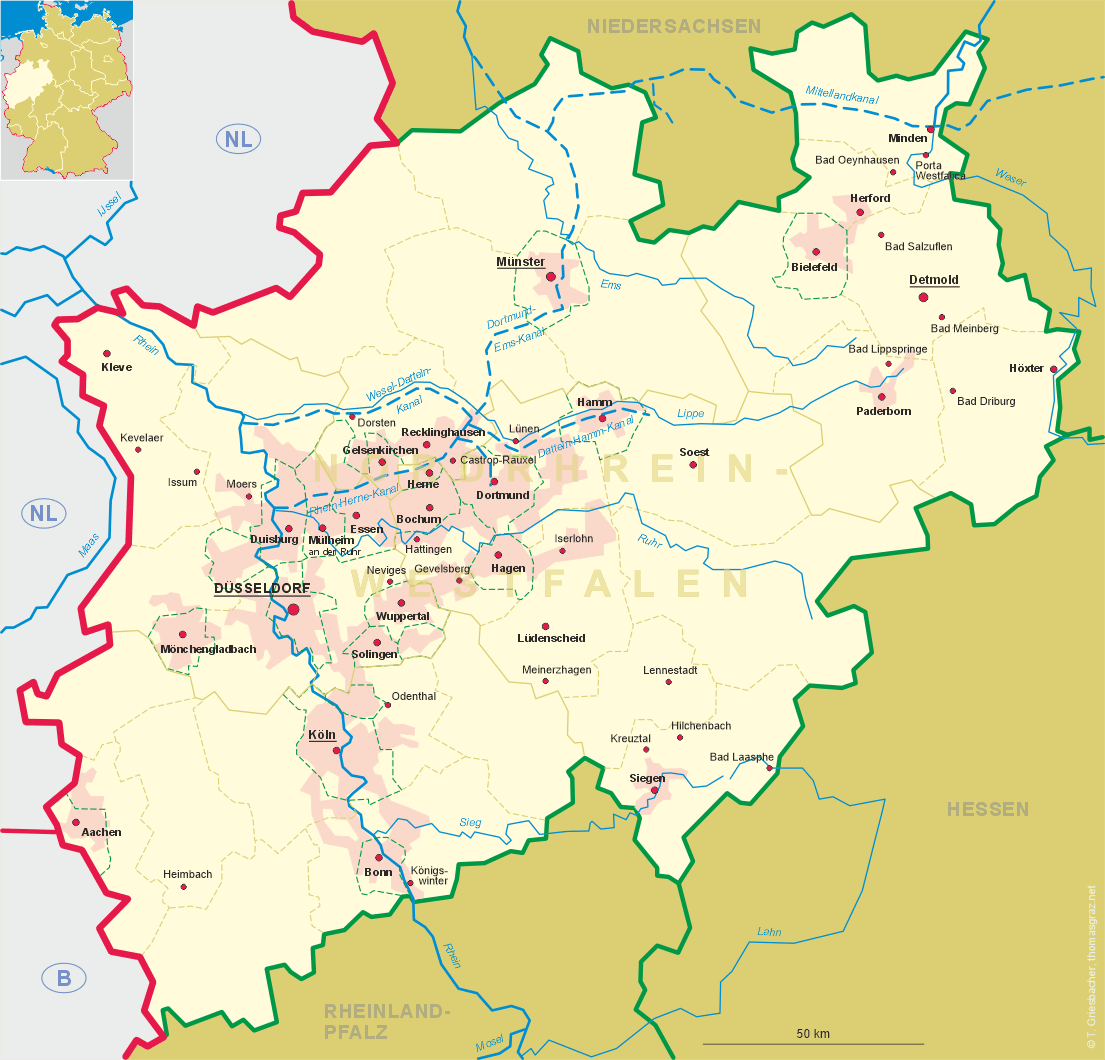
Mülheim an der Ruhr is situated at an elevation of 40 m on the river Ruhr between the neighbouring cities Duisburg to the west, Oberhausen to the north, Essen to the east and Ratingen to the south. The city of Mülheim has a population of about 170,900 (2016).
 Mulinhem was first mentioned in a written document dating from 1093. However, Broich castle, on the left side of the
river was probably already founded in 883/884. In 1372, after the death of the last lord of Broich, the domains came in
possession of the counts of Isenberg-Limburg. At the beginning of the 14th
century, the domains were partitioned into Limburg-Broich and Limburg-Styrum (both today parts of Mülheim). In 1508/1511
Limburg-Broich was inherited by the counts Daun-Falkenstein, while Limburg-Styrum later obtained the status of a territory
immediate to the empire (until 1806). During the course of the 17th and 18th centuries, the Duchy of Berg successfully
claimed the sovereignty over the area. With the death in 1682 of the last count of Daun-Falkenstein during the Eighty Years'
War, the domains fell to the counts (1779 princes) of Leiningen. The industrialisation of Mülheim began around 1770
when the river Ruhr was expanded to a waterway. Coal trading became important after 1780 when a river lock at Mülheim
had made it possible to navigate the upper part of the river. Two years after the foundation of the French Grand Duchy of
Berg, Mülheim was declared a muncipality. Together with the entire grand duchy, Mülheim became part of Prussia
following the Congress of Vienna (1815). In 1846, Mülheim obtained the status of a town by
Prussian law. Between 1850 and 1890 the city developed from being a shipping town into an industrial town. Steel production
using coking coal began in 1849, the first briquette factory opened in 1861. Coal mining within Mülheim, however,
later proved not being as productive as ogther large mines in the Ruhr area. The town was connected to the
Berg and Mark Railroad in 1862 and to the Ruhr Valley Railroad in 1872–1882. August Thyssen founded his later famous
steel company in 1871. Mülheim became the cengre of a district in 1873 (the western part of which was separated
in 1887 as district Ruhrort). In 1904, Mülheim became a city independent of the district. During World War II,
about 65% of the city was destroyed by Allied bomb raids. The second half of the 20th century brought a serious change in
the econommic life. The last steel factory closed in 1964, and two years later coal mining also was terminated.
Mulinhem was first mentioned in a written document dating from 1093. However, Broich castle, on the left side of the
river was probably already founded in 883/884. In 1372, after the death of the last lord of Broich, the domains came in
possession of the counts of Isenberg-Limburg. At the beginning of the 14th
century, the domains were partitioned into Limburg-Broich and Limburg-Styrum (both today parts of Mülheim). In 1508/1511
Limburg-Broich was inherited by the counts Daun-Falkenstein, while Limburg-Styrum later obtained the status of a territory
immediate to the empire (until 1806). During the course of the 17th and 18th centuries, the Duchy of Berg successfully
claimed the sovereignty over the area. With the death in 1682 of the last count of Daun-Falkenstein during the Eighty Years'
War, the domains fell to the counts (1779 princes) of Leiningen. The industrialisation of Mülheim began around 1770
when the river Ruhr was expanded to a waterway. Coal trading became important after 1780 when a river lock at Mülheim
had made it possible to navigate the upper part of the river. Two years after the foundation of the French Grand Duchy of
Berg, Mülheim was declared a muncipality. Together with the entire grand duchy, Mülheim became part of Prussia
following the Congress of Vienna (1815). In 1846, Mülheim obtained the status of a town by
Prussian law. Between 1850 and 1890 the city developed from being a shipping town into an industrial town. Steel production
using coking coal began in 1849, the first briquette factory opened in 1861. Coal mining within Mülheim, however,
later proved not being as productive as ogther large mines in the Ruhr area. The town was connected to the
Berg and Mark Railroad in 1862 and to the Ruhr Valley Railroad in 1872–1882. August Thyssen founded his later famous
steel company in 1871. Mülheim became the cengre of a district in 1873 (the western part of which was separated
in 1887 as district Ruhrort). In 1904, Mülheim became a city independent of the district. During World War II,
about 65% of the city was destroyed by Allied bomb raids. The second half of the 20th century brought a serious change in
the econommic life. The last steel factory closed in 1964, and two years later coal mining also was terminated.
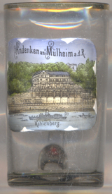
The picture on glass no. 3368 shows a view of
 Kahlenberg
Another glass in this collection is a souvenir from
Mülheim am Rhein, a city district of Cologne.
[https://de.wikipedia.org/wiki/Mülheim_an_der_Ruhr, https://en.wikipedia.org/wiki/Mülheim;
https://de.wikipedia.org/wiki/Kahlenberg_(Mülheim)]
![[scale]](lineal.jpg)