
|
|
| SCHWEIZ / SUISSE / SVIZZERA / SVIZRA | SWITZERLAND |
| Appenzell Ausserrhoden / Appenzell Rhodes-Extérieures / Appenzello Esterno / Appenzell Dadora | Appenzell Outer Rhodes |
map →
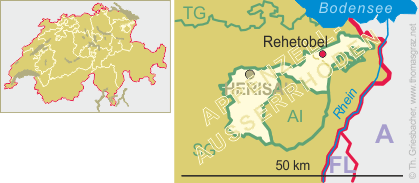
 Rehetobel is situated at an elevation of 953 m in the Vorderland region of the Swiss canton
Appenzell Ausserrhoden. The municipality has a population of about 1,800 (2016).
Rehetobel is situated at an elevation of 953 m in the Vorderland region of the Swiss canton
Appenzell Ausserrhoden. The municipality has a population of about 1,800 (2016).
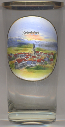
Rechtobel was first mentioned in 1463. After the Appenzell Wars (1401–1429) it became part of the Rhode Trogen. At first it belonged to the parish of Goldach, from 1463 to the parish of Trogen. Although Trogen resisted, Rehetobel became an indepent municipality and parish in 1669. Clothmaking was an important factor for the economy from the 18th century onwards. Tourism became important in the late 19th century.
The  church was built in 1667–1669 and later rebuilt in 1737 and 1890.
[https://de.wikipedia.org/wiki/Rehetobel, http://mobile.hls-dhs-dss.ch/m.php?lg=d&article=D1308.php]
![[scale]](lineal.jpg)