
|
|
| SCHWEIZ / SUISSE / SVIZZERA / SVIZRA | SWITZERLAND |
| Bern / Berne / Berna / Berna |
map →
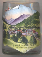 Gstaad is situated at an elevation of 1,050 m in the Berner Oberland area. Gstaad has a population of
about 9,200 and is part of the municipality of Saanen.
Gstaad is situated at an elevation of 1,050 m in the Berner Oberland area. Gstaad has a population of
about 9,200 and is part of the municipality of Saanen.
During the Middle Ages it was part of the district of Saanen (Gessenay) belonging to the Savoyard county of Gruyère. The village core developed at the fork in the trails into the Valais and Vaud. The village was dominated by cattle farming and agriculture until the great fire of 1898. It was then rebuilt to support the growing tourism industry that began after the construction of the Montreux–Oberland Bernois rail road in 1905 and the construction of ski runs; the Ski Club of Saanen open in 1905 followed in 1907 by the Ski Club of Gstaad. The Gstaad Palace opened in 1913 as Gstaad's first luxury hotel. The first ski school in Gstaad opened in 1923 and in a short time there were more than 1,000 hotel beds in the region. The first ski lifts at Funi opened in 1934–34, and was followed by a number of gondolas, ski and chair lifts. In 1942 the Saanen-Gstaad airfield was opened for military and civil aviation. Helicopter rides were added later and in 1980 balloon flights became available as well. During the World Wars and the Great Depression, the tourism industry suffered and many hotels closed. After World War II, many of the large hotels remained closed, but they were replaced with a number of smaller non-hotel accommodation (chalets, apartment houses, residences). Most of the modern resorts and small hotels are built out of wood and retain traditional design elements.
The mountain depicted in the background is the  Oldenhorn
[https://de.wikipedia.org/wiki/Gstaad, http://en.wikipedia.org/wiki/Gstaad;
https://fr.wikipedia.org/wiki/Oldehore, https://de.wikipedia.org/wiki/Oldenhorn]
![[scale]](lineal.jpg)