
|
|
| DEUTSCHLAND | GERMANY |
| Bundesland: Baden-Württemberg | |
| Regierungsbezirk: Stuttgart | |
| Landkreis: Schwäbisch Hall |
map →

Kreßberg is situated at an elevation of 470 m in the east of the district Schwäbisch Hall at the border to Bavaria. The municipality consists of 33 villages and hamlets and has a population of about 4,000 (2019).
The oldest settlements within the area of today's municipality were founded between the 7th and 9th century. The present municipality was created on 1 January 1973 by merging the former municipalities of Waldtann, Marktlustenau, Mariäkappel und Leukershausen.
Mergenbruon was first mentioned in 1357, Zur Kappelen zu Mergenbrunn in 1366 and Mariencappel in 1465. It belonged at first to the domains of Lohr, later to Hohenlohe, and in 1399 it came in possession of the burgraves of Nuremberg (later margraves of Brandenburg-Ansbach). Together with Brandenburg-Ansbach and -Bayreuth it became part of Prussia in 1792. In 1806 the former margraviate became part of Bavaria. In 1810 Mariäkappel became part of Württemberg's district Crailsheim (merged with the distict Schwäbisch Hall in 1973). In 1973 Mariäcappel was merged with the neighbouring municipalities Waldtann, Marktlustenau and Leukershausen into the new municipality of Kreßberg.
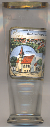
The  church of Our Lady [left, no. 3516: bottom left picture]
was first mentioned in 1331 as part of the parish Crailsheim. In 1481 it became an independent parish. The
present church was built in 1480/1481, the tower was rebuilt in 1593. The church is the Protestant parish church of
Maräkappel.
church of Our Lady [left, no. 3516: bottom left picture]
was first mentioned in 1331 as part of the parish Crailsheim. In 1481 it became an independent parish. The
present church was built in 1480/1481, the tower was rebuilt in 1593. The church is the Protestant parish church of
Maräkappel.
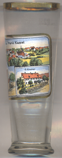
The building depicted on the bottom right picture on glass no. 3516 is labeled O. Krammer.
[https://de.wikipedia.org/wiki/Kreßberg;
https://www.leo-bw.de/web/guest/detail-gis/-/Detail/details/ORT/labw_ortslexikon/3518/Mari%C3%A4kappel+-+Altgemeinde~Teilort]
![[scale]](lineal.jpg)