
|
|
| DEUTSCHLAND | GERMANY |
| Bundesland: Baden-Württemberg | |
| Regierungsbezirk: Freiburg | |
| Landkreis: Breisgau-Hochschwarzwald |
map →

 At 1,493 metres, the Feldberg in the Black Forest is the highest mountain in Baden-Württemberg,
and the highest in Germany outside of the Alps. The local municipality of Feldberg (Schwarzwald) was named after the
mountain.
At 1,493 metres, the Feldberg in the Black Forest is the highest mountain in Baden-Württemberg,
and the highest in Germany outside of the Alps. The local municipality of Feldberg (Schwarzwald) was named after the
mountain.
The Feldberg is situated southeast of Freiburg im Breisgau and is surrounded by the municipalities of Hinterzarten (northeast), Titisee (east), Menzenschwand (south), Bernau (also south) and Todtnau (southwest). About two kilometres southeast of the summit lies the village of Feldberg (Schwarzwald) (1,277 metres).
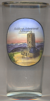
The  Feldberg Tower [left] is located on the Seebuck, a secondary summit
(1,448 m) of the Feldberg, about 1,7 km southeast of the main summit. The tower was built in 1955 as a
radio tower. When a new television tower was built on the Feldberg in 2003, the old tower was preserved and since
then is used as a lookout tower. (The picture on glass no. 3590 erroneously give the elevation as 1,500 m.)
Feldberg Tower [left] is located on the Seebuck, a secondary summit
(1,448 m) of the Feldberg, about 1,7 km southeast of the main summit. The tower was built in 1955 as a
radio tower. When a new television tower was built on the Feldberg in 2003, the old tower was preserved and since
then is used as a lookout tower. (The picture on glass no. 3590 erroneously give the elevation as 1,500 m.)
[https://en.wikipedia.org/wiki/Feldberg_(Black_Forest);
https://de.wikipedia.org/wiki/Seebuck#Feldbergturm, https://de.wikipedia.org/wiki/Sender_Feldberg]
![[scale]](lineal.jpg)