
|
|
| ČESKÁ REPUBLIKA | CZECH REPUBLIC |
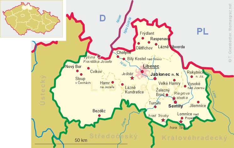
| Liberecký kraj | Liberec region |
| Okres: Semily |
map →
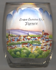
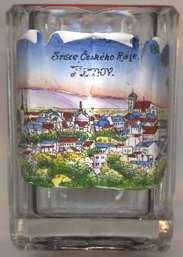
Turnov (in German: Turnau) is situated at an elevation of 260 m on the river Jizera in the district Semily, west of the nature reserve area Český ráj ('Bohemian paradise'). The municipality has a population of about 14,300 (2019). The picture on glass no. 3673 [below left] is labeled Srdce Českého Ráje ('Heart of the Bohemian Paradise').
 Turnov was founded as a Bohemian town in 1272 on a spur of rock overlooking the Jizera River. During the Middle Ages, Turnov
came into the possession of the Wartenberg and Smiřický noble houses. The medieval town was frequently
hit by fires: it was burnt by Lusatian crusaders in 1468 and during the Thirty Years' War by Swedes in
1643, as well as a conflagration in 1707. The first European technical school for the processing of gemstones, metals, and
jewelry was founded in Turnov in 1882 and still exists as one of the world's best schools of this type.
Turnov was founded as a Bohemian town in 1272 on a spur of rock overlooking the Jizera River. During the Middle Ages, Turnov
came into the possession of the Wartenberg and Smiřický noble houses. The medieval town was frequently
hit by fires: it was burnt by Lusatian crusaders in 1468 and during the Thirty Years' War by Swedes in
1643, as well as a conflagration in 1707. The first European technical school for the processing of gemstones, metals, and
jewelry was founded in Turnov in 1882 and still exists as one of the world's best schools of this type.
The Roman Catholic  church of the Nativity of the Virgin Mary [background right]
was built between 1825 and 1853 as one of the first neo-Gothic churches in Europe. The massive three-aisled building with
the unfinished tower has become a characteristic landmark of the city. A first wooden church was built with the
Dominican monastery in the late 13th century. During the Hussite Wars (1423–1424) the church was burnt down. The
rebuilt temple was used by the Unity of Brethren from 1550 until 1620, burned down again in 1643 and subsequently repaired.
Due to the poor condtion of the building, it was decided in the 1820s to replace it with a new church building. Its
construction began in 1825, the architect was Martin Hausknecht from Vienna. The construction
was finished in 1853.
church of the Nativity of the Virgin Mary [background right]
was built between 1825 and 1853 as one of the first neo-Gothic churches in Europe. The massive three-aisled building with
the unfinished tower has become a characteristic landmark of the city. A first wooden church was built with the
Dominican monastery in the late 13th century. During the Hussite Wars (1423–1424) the church was burnt down. The
rebuilt temple was used by the Unity of Brethren from 1550 until 1620, burned down again in 1643 and subsequently repaired.
Due to the poor condtion of the building, it was decided in the 1820s to replace it with a new church building. Its
construction began in 1825, the architect was Martin Hausknecht from Vienna. The construction
was finished in 1853.
The ruins of
[https://de.wikipedia.org/wiki/Turnov, https://en.wikipedia.org/wiki/Turnov, https://cs.wikipedia.org/wiki/Turnov;
https://cs.wikipedia.org/wiki/Kostel_Narození_Panny_Marie_(Turnov);
https://de.wikipedia.org/wiki/Schloss_Hrub%C3%A1_Sk%C3%A1la;
https://en.wikipedia.org/wiki/Trosky_Castle]
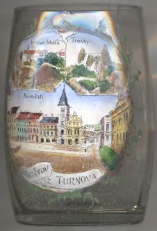
The Hruba Skalá castle [near left, no.͇4556: top left picture] is located high on a sandstone cliff
above the neighbouring village of Hruba Skalá, about 6 km southeast of Turnov. The castle was built in the 2nd half of the 16th century
in Renaissance style in place of a castle that had first been mentioned in 1353. In 1859 it was again rebuilt in Gothic revival style. After the end of
World War II the former owners were expropriated and the castle was used as a recreation home. Today it is used as a hotel.
Trosky castle [near left, no.͇4556: top right picture] are located on the summits of two
basalt vulcanic plugs, about 10 km southeast of Turnov within the municipality of Troskovice. The castle was establised in the 2nd half of the
14th century. During the Hussite Wars Trosky was a centre of the pro-Catholic sides. In 1648, during the Thirty Years' War (1618–1648) the
castle was burned down completely by the Imperial Army and left in ruins. In the 19th century, when there was some romantiv interest in the ruins,
some modifications such as stairs to one of the towers, were made. The castle is a landmark of the Bohemian Paradise region.
![[scale]](lineal.jpg) contact: webmaster
contact: webmaster