
|
|
| DEUTSCHLAND | GERMANY |
| Bundesland: Baden-Württemberg | |
| Regierungsbezirk: Stuttgart | |
| Landkreis: Böblingen |
map →

 Mötzingen is situated at an elevataion of 533 m about 23 km west of Tübingen,
44 km southwest of Stuttgart and 23 km southwest of the district town Böblingen.
The municipality has a population of about 3,700 (2018).
Mötzingen is situated at an elevataion of 533 m about 23 km west of Tübingen,
44 km southwest of Stuttgart and 23 km southwest of the district town Böblingen.
The municipality has a population of about 3,700 (2018).
The oldest traces of human settlements that have been found date from the Iron Age, beginning from ca. the 9th century BC. The oldest written document mentioning the place dates from 1094. Before 1810, Mötzingen for a brief period was part of the district Nagold, thereafter it was part of the district Herrenberg. Since 1938 it is part of the district Böblingen.
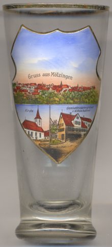
The Protestant  church of Sankt Mauritius [left, no. 3753: bottom left picture]
was built in 1792–1793 by the architect Johann Adam Groß (the Younger).
church of Sankt Mauritius [left, no. 3753: bottom left picture]
was built in 1792–1793 by the architect Johann Adam Groß (the Younger).
The the building depicted in the lower right picture on glass no. 3753 is labeled
Gemischtes Warengeschäft v[on] Wilhelm Kußmaul ('grocery store of
Wilhelm Kussmaul').
[https://de.wikipedia.org/wiki/M%ötzingen; https://www.moetzingen.de/index.php?id=30;
https://zeitreise-bb.de/mauritiuskirche-moetzingen/]
![[scale]](lineal.jpg)