
|
|
| ÖSTERREICH | AUSTRIA |
| Bundesland: Niederösterreich | Lower Austria |
| Bezirk: Krems an der Donau |
map →

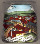 Gföhl is situated at an elevation of 579 m in the southern
Waldviertel region. It became an independent parish in 1332. The status of
a town was granted to Gföhl in 1990.
Gföhl is situated at an elevation of 579 m in the southern
Waldviertel region. It became an independent parish in 1332. The status of
a town was granted to Gföhl in 1990.
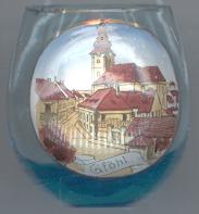
The  parish church Sankt Andreas [right]
was built 1615–1620 in Baroque style. The parish itself had been established in 1332.
parish church Sankt Andreas [right]
was built 1615–1620 in Baroque style. The parish itself had been established in 1332.
![[scale]](lineal.jpg)