
|
|
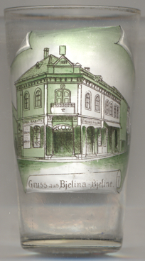
| BOSNA i HERCEGOVINA | BOSNIA and HERZEGOVINA |
| Regija: Бијељина / Bijeljina |
map →

 Bijeljina / Бијељина is situated at an elevation of 90 m in the border
triangle of Bosnia-Herzegovina, Croatia and Serbia. It is bounded in the north by the river Save and in the east by the
Drina. The municipality has a population of about 104,000 (2018).
Bijeljina / Бијељина is situated at an elevation of 90 m in the border
triangle of Bosnia-Herzegovina, Croatia and Serbia. It is bounded in the north by the river Save and in the east by the
Drina. The municipality has a population of about 104,000 (2018).
The earliest confirmed traces of human life in the area of today's Bijeljina date from the New Stone Age
(5000–3000 BC).
Although the name Bijeljina was first mentioned in 1446, this name was in regular use only after 1918. During the
Austro-Hungarian period, the town had the name Bjelina and, before that, Belina or Bilina.
In 1838, the first confessional elementary school was opened. A modern school building was built in 1902. In this school
Jovan Dučić, famous Herzegovinian Serb poet, writer and diplomat, worked between 1893 and 1895.
Due to its strategically important location, Bijeljina was one of the first places to be the scene of the Bosnian War
of 1992–1995. In April 1992, up to 1,000 civilians (mostly Bosniaks, i.e. Bosnian Muslims) were killed, the
non-Serbian population was completelly expelled, which is considered to have been the first step of ethnic cleansing in
Bosnia and Herzegovina. In March 1993, all 5 mosques of the town were blown up by the Serbian militia. The largest mosque
on the main square has now been rebuilt with funds from the European Union. The local Catholic church fell into disrepair
during this time, but remained undisturbed.
[https://de.wikipedia.org/wiki/Bijeljina, https://en.wikipedia.org/wiki/Bijeljina]
![[scale]](lineal.jpg)