
|
|
| PORTUGAL | |
| distrito de Lisboa |
map →
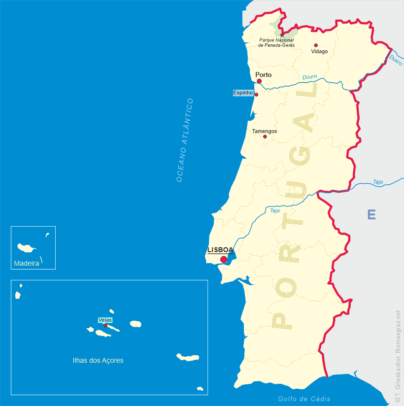
Lisboa is the capital and the largest city of Portugal, with an estimated population of about 508,400 (2017). Lisbon's urban area extends beyond the city's administrative limits with a population of around 2.0 million people, being the 10th-most populous urban area in the European Union. About 2.8 million people live in the Lisbon metropolitan area, which represents approximately 27% of the country's population. It is mainland Europe's westernmost capital city and the only one along the Atlantic coast. Lisbon lies in the western Iberian Peninsula on the Atlantic Ocean and the River Tagus. The westernmost portions of its metro area, the Portuguese Riviera, form the westernmost point of Continental Europe, culminating at Cabo da Roca. Lisbon's Belém Tower and Jerónimos monastery were declared a UNESCO World Heritage site in 1983 (see also list of other heritage sites in this collection) and were also included in the registry of the 'Seven Wonders of Portugal' in 2007. In 1994 Lisbon was European Capital of Culture (see also list of European Capitals of Culture in this collection).
Lisbon is one of the oldest cities in the world, and the second-oldest European capital city (after Athens), predating other modern European capitals by centuries. Julius Caesar made it a municipium called Felicitas Julia, adding to the name Olissipo. After the fall of the Roman Empire it was ruled by a series of Germanic tribes from the 5th century; later it was captured by the Moors in the 8th century. In 1147 Afonso (Alfonso Henriques, 'the Conquerer') conquered the city and since then it has been the political, economic and cultural center of Portugal.
 The
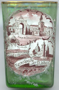
The  Praça do Comércio [left, no. 3970: top picture], facing the harbour, is one of the
largest squares in Portugal, with 175 by 175 metres, i.e. 30,600 m². Facing the Tejo (Tagus) to the South, the square is still commonly known in
Portuguese as Terreiro do Paço ('Palace Yard'), as it hosted the Paço da Ribeira (Royal Palace of Ribeira) until it was destroyed by the great
1755 Lisbon earthquake (the subway station located there is still called after the old name of the square). On 1 February 1908, the square was the scene of
the assassination of Carlos I, the penultimate King of Portugal.
Praça do Comércio [left, no. 3970: top picture], facing the harbour, is one of the
largest squares in Portugal, with 175 by 175 metres, i.e. 30,600 m². Facing the Tejo (Tagus) to the South, the square is still commonly known in
Portuguese as Terreiro do Paço ('Palace Yard'), as it hosted the Paço da Ribeira (Royal Palace of Ribeira) until it was destroyed by the great
1755 Lisbon earthquake (the subway station located there is still called after the old name of the square). On 1 February 1908, the square was the scene of
the assassination of Carlos I, the penultimate King of Portugal.
The monument for King José I [foreground right] was created in 1775 by the sculptor Joaquim
Machado de Castro. JoséI (also named 'O Reformador', 'the Reformer', was born in 1714. He reigned Portugal from 1750 until his death in 1777.
The Arco Triunfal da Rua Augusta [left, no. 3970: background left], which links the square with
another tradiotional Lisbon square, the Rossio, was already planned after the Lisbon earthquake by the architect Eugénio dos Santos de Carvalho,
but it was only realised in 1875 following the design by Veríssimo da Costa.
The Basílica da Estrela (Real Basílica e Convento do Santíssimo Coração de Jesus)
(Royal Basilica and Convent of the Most Sacred Heart of Jesus) [left, no. 3970: bottom right picture] was the first church in the
world dedicated to the Sacred Heart of Jesus. It was ordered to be built as the fulfilment of a vow by Queen Maria I of Portugal. Shortly after her
wedding to her uncle Infante Peter of Braganza (later king Pedro III) in 1760, she vowed to build a church if she was given the grace of bearing
children that would assure the succession of the House of Bragança. Only after acceding to the throne in 1777 could she afford to see to the
fulfilment of her vow. Construction began in 1779, the architect was Mateus Vicente de Oliveira. The church was completed in 1789.
The Aqueduto das Águas Livres ('Aqueduct of the Free Waters') [left, no. 3970: bottom left picture]
is one of the most remarkable examples of 18th-century Portuguese engineering. The main course of the aqueduct covers 18 km, but the whole network of
canals extends through nearly 58 km. The city of Lisbon has always suffered from lack of drinking water, and King João V decided to build
an aqueduct to bring water from sources in the parish of Caneças, in the modern municipality of Odivelas. The project was paid for by a special sales
tax on beef, olive oil, wine, and other products. Construction started in 1731. The centrepiece of the construction are the arches over the Alcantara
valley. A total of 35 arches cross the valley, covering 941 m. The tallest arches reach a height of 65 m, and many are pointed, reminiscent
of arches in Gothic style. It is considered a masterpiece of engineering in the Baroque period. In 1748, although the project was still unfinished, the
aqueduct finally started to bring water to the city of Lisbon.
[https://en.wikipedia.org/wiki/Lisbon;
https://en.wikipedia.org/wiki/Pra%C3%A7a_do_Com%C3%A9rcio;
https://en.wikipedia.org/wiki/Estrela_Basilica;
https://en.wikipedia.org/wiki/%C3%81guas_Livres_Aqueduct]
![[scale]](lineal.jpg)