
|
|
| DEUTSCHLAND | GERMANY |
| Bundesland: Baden-Württemberg | |
| Regierungsbezirk: Karlsruhe | |
| Landkreis: Rastatt |
map →

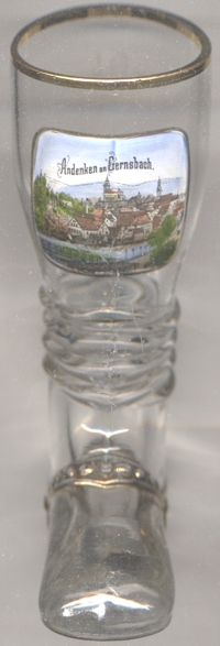
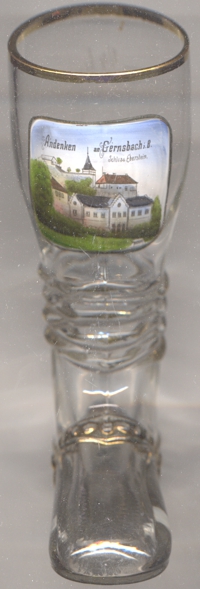
Gernsbach is situated at an elevation of 174 m on the river Murg in the norther Schwarzwald (Black Forest) region in the west of Germany's state of Baden-Württemberg, about 15 km southeast of the district town Rastatt and about 61 km west of the state's capital, Stuttgart. The municipality has a population of about 14,100 (2020).
No permanent settlement in this location is verified before the 12th century. The oldest known written document that mentions
Genrespach dates from 1218. At this time already thera was a differentiation between two settlements, one ('Marktdorf') that had the right
to hold markets, and one ('Kirchdorf') that was the location of a church. A document of 1243, which confirms the establishment of Gernsdorf as
a parish, for the first time mentions the place as an 'oppidum', i.e. a town. After 20 years of conflicts between the counts of Württemberg
and the counts of Eberstein, on half of the county of Eberstein and half of castle Neu-Eberstein had to be sold to the margraves of
Baden. The continuing conflicts between the counts of Eberstein and the counts of Baden was resolved by a contract in 1506,
replacing the divided ownership of the region by a condominium. De facto, the area became part of Baden, which was confirmed in 1508. When the counts
of Eberstein became extinct in 1660, Gernsbach became the seat of three bailiffs, representing Baden, Württember, and the prince bishopric of
 Speyer. Württemberg renounced of its rights in 1753, and in 1803 Gernsbach finally came under the unitary administration Baden.
In 1872 the district Gernsbach was dissolved and became part of the Rastatt. The railway line from Gernsbach to Rastatt opened in 1869, the Murg valley
railroad to Freudenstadt was finally completed only in 1928. The neighbouring community of Scheuern was incorporated into
Gernsbach in 1936, Staufenberg followed in 1971, Lautenbach in 1973, Hilpertsau and Obertsrot (united in 1970 to the municipality Obertsrot) in 1974,
and Reichental finally in 1975.
Speyer. Württemberg renounced of its rights in 1753, and in 1803 Gernsbach finally came under the unitary administration Baden.
In 1872 the district Gernsbach was dissolved and became part of the Rastatt. The railway line from Gernsbach to Rastatt opened in 1869, the Murg valley
railroad to Freudenstadt was finally completed only in 1928. The neighbouring community of Scheuern was incorporated into
Gernsbach in 1936, Staufenberg followed in 1971, Lautenbach in 1973, Hilpertsau and Obertsrot (united in 1970 to the municipality Obertsrot) in 1974,
and Reichental finally in 1975.
The  Liebfrauenkirche (Church of Our Lady) [left, no. 4168: background centre] is the Catholic
parish church of Gernsbach. The church was founded in 1388. A document dating from 1487 suggests that the church at that time was a pilgrimage site.
When Gernsbach together with the county of Eberstein became Protestant, the church remained Catholic. An agreement from 1626 allowed both religions
in Gernsbach. The regulation that is still valid today, assigning the St. Jakobskirche to the Protestants and the Liebfrauenkirche to the Catholics,
dates back to 1640. The church was thoroughly renovated and enlarged in 1833. A further renovation in 1971–1972 aimed at removing the neo-Gothic
additions of the 19th century in favour of the original late Gothic style.
Liebfrauenkirche (Church of Our Lady) [left, no. 4168: background centre] is the Catholic
parish church of Gernsbach. The church was founded in 1388. A document dating from 1487 suggests that the church at that time was a pilgrimage site.
When Gernsbach together with the county of Eberstein became Protestant, the church remained Catholic. An agreement from 1626 allowed both religions
in Gernsbach. The regulation that is still valid today, assigning the St. Jakobskirche to the Protestants and the Liebfrauenkirche to the Catholics,
dates back to 1640. The church was thoroughly renovated and enlarged in 1833. A further renovation in 1971–1972 aimed at removing the neo-Gothic
additions of the 19th century in favour of the original late Gothic style.
castle Eberstein [right, no. 4169], also called Neu-Eberstein, was first mentioned
in 12nbsp;century the castle was enlarged by the addition of the fountains, stair towers, the upper floor of the residential building, an archival building,
a castle chapel and various ward walls. In the early 17th century, a new gatehouse, the outworks to the east and west, and further ward walls were
added. After 1660 the castle became the seat of administrators. In 1691 part of the complex burned down. After that, the castle was only used as a workshop
and warehouse. Beginning in 1802, the castle was rebuilt in Gothic revival style. The keep obtained its current appearance in 1951.
[https://de.wikipedia.org/wiki/Gernsbach;
https://de.wikipedia.org/wiki/Liebfrauenkirche_(Gernsbach);
https://de.wikipedia.org/wiki/Schloss_Eberstein_(Gernsbach)]
![[scale]](lineal.jpg)