
|
|
| ČESKÁ REPUBLIKA | CZECH REPUBLIC |
| Ústecký kraj | Ústí nad Labem region |
| Okres: Most |
map →
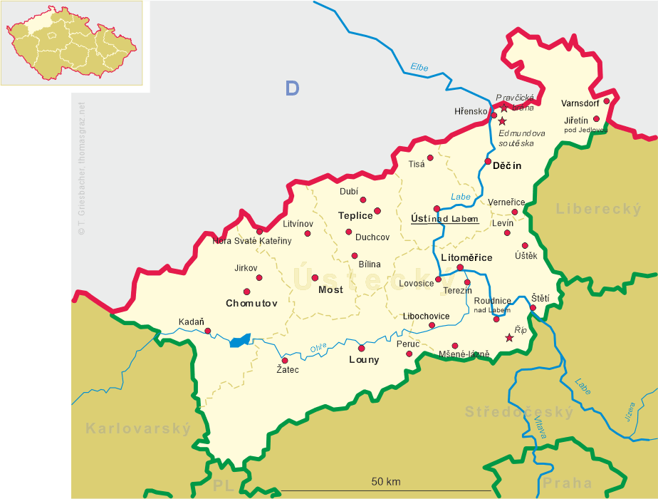
Hora Svaté Kateřiny (German: Katharinaberg) is situated at an elevation of 645 m in the Bohemian Ore Mountains (Kružné Hory), directly at the border to Germany opposite the German community of Deutschkatharinenberg (part of the municipality of Deutschneudorf), about 18 km northwest of the district town Most and about 20 km west of the regional capital, Ústí nad Labem. The municipality has a population of about 440 (2021).
 The earliest known mention of the settlement dates from 1480. Silver, copper, tin and lead were mined here since the 16th century, leading to a
significant boom of the community which in 1528 was elevated to the status of a royal mining town. The privileges were revoked in the early
17th century. Instead of mining, weaving of linen was taken up on a large scale. During the Thirty Years' War (1618–1648) the town suffered
from troops passing through or taking quarters here. In the early 18th century, knitting supplemented the linen industry, and inhabitants of
St. Katharinaberg also supplied the cloth manufacturers in Oberleutensdorf (today Litvínov). Mining flourished again
until the late 1760s, but ceased completely in 1786. During the Seven Years' War the town was raided 14 times by Prussian troops (1756–1763)
the town was raided 14 times by Prussian troops. In 1850, the town became the seat of a judicial district. Before World War II 98% of the population
were of German ethnicity, but after the war the Germans were expelled and the status as a town was removed. The municipality only regained this status
in 2008.
The earliest known mention of the settlement dates from 1480. Silver, copper, tin and lead were mined here since the 16th century, leading to a
significant boom of the community which in 1528 was elevated to the status of a royal mining town. The privileges were revoked in the early
17th century. Instead of mining, weaving of linen was taken up on a large scale. During the Thirty Years' War (1618–1648) the town suffered
from troops passing through or taking quarters here. In the early 18th century, knitting supplemented the linen industry, and inhabitants of
St. Katharinaberg also supplied the cloth manufacturers in Oberleutensdorf (today Litvínov). Mining flourished again
until the late 1760s, but ceased completely in 1786. During the Seven Years' War the town was raided 14 times by Prussian troops (1756–1763)
the town was raided 14 times by Prussian troops. In 1850, the town became the seat of a judicial district. Before World War II 98% of the population
were of German ethnicity, but after the war the Germans were expelled and the status as a town was removed. The municipality only regained this status
in 2008.
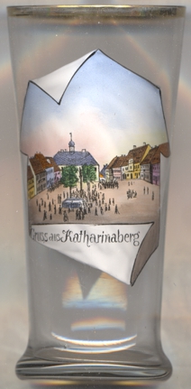
The  town hall [left, no. 4187: background] was built after 1750. It was also the set of the
district court from 1850 until 1939. The clock in the turret was installed in 1894.
town hall [left, no. 4187: background] was built after 1750. It was also the set of the
district court from 1850 until 1939. The clock in the turret was installed in 1894.
The Marian column [left, no. 4187: centre] was created in 1714. It is also called the Plague Column
because it was built during plague epidemics, when more than half of the population died. The double figure of the Immaculate Conception, looking
both west and east, stands on a globe with a snake and a crescent moon.
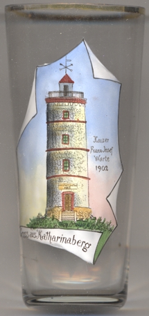 The lookout tower [near left, no. 4188] on the summit of Růžový vrch (Rosenberg,
729 m) was planned in 1898 and was opened to the public in 1902. The tower has a height of 16 metres. Glass no. 4188 dates from the year
of the opening, as it is labeled Kaiser-Franz-Josef-Warte 1902, named for Emperor Franz Joseph I of Austria. After 1918, the tower was renamed
Jahnwarte for the German gymnastics educator and nationalist Friedrich Ludwig Jahn. The tower was renovated and reopened in 2002.
The lookout tower [near left, no. 4188] on the summit of Růžový vrch (Rosenberg,
729 m) was planned in 1898 and was opened to the public in 1902. The tower has a height of 16 metres. Glass no. 4188 dates from the year
of the opening, as it is labeled Kaiser-Franz-Josef-Warte 1902, named for Emperor Franz Joseph I of Austria. After 1918, the tower was renamed
Jahnwarte for the German gymnastics educator and nationalist Friedrich Ludwig Jahn. The tower was renovated and reopened in 2002.
[https://de.wikipedia.org/wiki/Hora_Svat%C3%A9_Kate%C5%99iny, https://en.wikipedia.org/wiki/Hora_Svat%C3%A9_Kate%C5%99iny;
http://www.soupispamatek.com/okres_most/foto/horasvatekateriny/horasvatekateriny.htm;
https://krusnohori-bez-hranic.cz/pamatniky-hora-sv-kateriny-st-katharinaberg;
https://grenzenloses-erzgebirge.de/aussichtsturm-hora-svate-kateriny-st-katharinenberg,
https://erz.krusnohorci.cz/ausflugstipps/58-aussichtsturm-in-katharinaberg, https://www.osterzgebirge.org/gebiete/23_7.html]
![[scale]](lineal.jpg)