
|
|
| UNITED STATES OF AMERICA | |
| MASSACHUSETTS | |
| Bristol County |
map →
Fall River is situated at an elevation of 40 km at the mouth of the Taunton River at Mount Hope Bay, the northeasternmost part of Narragansett Bay. The southern city limit is also the state line with Rhode Island. Fall River's population was 94,000 at the 2020 United States Census, making it the tenth-largest city in the state. Fall River is known for Portuguese culture, its numerous 19th-century textile mills and Battleship Cove, home of the world's largest collection of World War II naval vessels (including the battleship USS Massachusetts). Fall River's official motto is "We'll Try", dating back to the aftermath of the Great Fire of 1843.
At the time of the establishment of the Plymouth Colony in 1620, the area that would one day become Troy City was inhabited by the Pokanoket Wampanoag tribe, headquartered at Mount Hope in what is now Bristol, Rhode Island. The "falling" river that the city's name refers to is the Quequechan River (pronounced "quick-a-shan" by locals) which flows through the city before draining into the bay. In 1653, Freetown was settled at Assonet Bay by members of the Massachusetts Bay Colony, which included the northern part of what is now Fall River. In 1683, Freetown was incorporated as a town within the colony. The southern part of what is now Fall River was incorporated as the town of Tiverton as part of the Massachusetts Bay Colony in 1694, a few years after the merger with Plymouth Colony. In 1746, in the settlement of a colonial boundary dispute between Rhode Island and Massachusetts, Tiverton was annexed to Rhode Island, along with Little Compton and what is now Newport County, Rhode Island. The boundary was then placed approximately at what is now Columbia Street. During the 18th century, the area consisted mostly of small farms and relatively few inhabitants. In 1778, the Battle of Freetown, was fought here during the American Revolutionary War (1775–1783) after British raids badly damaged Bristol and Warren. In 1803, Fall River was separated from Freetown and officially incorporated as its own town. A year later, Fall River changed its name to Troy. This name was used for 30 years and was officially changed back to Fall River in 1834. In July 1843, the first great fire in Fall River's history destroyed much of the town center. During this time, the southern part of what is now Fall River (south of Columbia Street) remained part of Tiverton, Rhode Island. In 1854, Fall River was officially incorporated as a city. In 1856, the town of Tiverton, Rhode Island voted to split off its industrial northern section as Fall River, Rhode Island. In 1861, after decades of dispute, the United States Supreme Court moved the state boundary to what is now State Avenue, unifying both Fall Rivers as a city in Massachusetts.
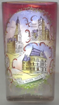
The  old City Hall [left, no. 4326: left picture], built in the 19th century directly over the
Quequechan River, had survived two fires, but was demolished in 1962 for cinstruction of Interstate 195, which cut through the heart of downtown
Fall River. As part of the highway project, the river was diverted into an underground culvert which parallels the highway, along the south side of the
current city hall. Two granite columns from the front of the old city hall are located across from the current building (opened in 1976), along Sullivan
Drive, next to the Academy Building. The eagle which topped the spire of the old city hall is currently located in the foyer of the new building.
old City Hall [left, no. 4326: left picture], built in the 19th century directly over the
Quequechan River, had survived two fires, but was demolished in 1962 for cinstruction of Interstate 195, which cut through the heart of downtown
Fall River. As part of the highway project, the river was diverted into an underground culvert which parallels the highway, along the south side of the
current city hall. Two granite columns from the front of the old city hall are located across from the current building (opened in 1976), along Sullivan
Drive, next to the Academy Building. The eagle which topped the spire of the old city hall is currently located in the foyer of the new building.
The Bristol County Superior Court [top right picture] is located at 441 N. Main Street. It is a monumental
three story granite structure, with a five-story square tower at one corner. The oldest portion of the building, the main courthouse was designed by
New Bedford architect Robert H. Slack, and was completed in 1889. The building is Fall River's finest and most imposing example of Richardsonian
Romanesque architecture. The building was listed on the National Register of Historic Places in 1983.
The post office building and customs house[bottom right picture] on the corner of Bedford Street and Second
Street was built as an impressive granite structure in 1875 to the designs of William A. Potter. It no longer exists.
[https://de.wikipedia.org/wiki/Fall_River_(Massachusetts), https://en.wikipedia.org/wiki/Fall_River,_Massachusetts;
https://en.wikipedia.org/wiki/Fall_River_Government_Center;
https://en.wikipedia.org/wiki/Bristol_County_Superior_Court_%28Fall_River,_Massachusetts%29;
https://www.sec.state.ma.us/mhc/mhcpdf/regionalreports/SoutheasternMA.pdf, https://www.loc.gov/item/2005693133/,
https://www.sailsinc.org/durfee/earl6.pdf]
![[scale]](lineal.jpg)