
|
|
| FRANCE | FRANCE |
| région: Provence-Alpes-Côte d'Azur | |
| département: 6, Alpes-Maritimes |
map →
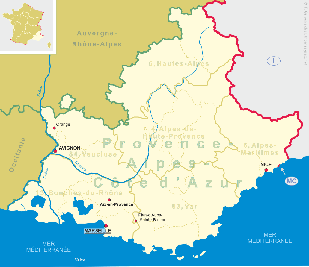
Nice (Nissart Occitan: Niça or more commonly Nissa) is situated at the French Mediterranean coast, about 30 km from the Italian border. At a population of about 344,000 (2014), it is the second-most populous city in the région Provence-Alpes-Côte d'Azur after Marseille and the fifth city after Paris, Marseille, Lyon and Toulouse. Nice is the capital (préfecture) of the département Alpes-Maritimes and the capital (chef-lieu) of the arrondissement Nice.
The first known hominid settlements in the Nice area date back about 400,000 years. Nice (Nicaea) was probably founded around 350 BC by the Greeks of Massalia (Marseille), and was given the name of Nikaia (Νίκαια) in honour of a victory over the neighbouring Ligurians. In the 7th century, Nice joined the Genoese League formed by the towns of Liguria. During the Middle Ages, Nice participated in the wars and history of Italy. As an ally of Pisa it was the enemy of Genoa, and both the King of France and the Holy Roman Emperor endeavoured to subjugate it; but in spite of this it maintained its municipal liberties. During the 13th and 14th centuries the city fell more than once into the hands of the Counts of Provence, but it regained its independence even though related to Genoa. In 1388 the commune placed itself under the protection of the Counts of Savoy and from then on participated, directly or indirectly, in the history of Savoy until 1860. Captured by France in 1691, Nice was restored to Savoy in 1696; but it was again besieged by the French in 1705, and in the following year its citadel and ramparts were demolished. The Treaty of Utrecht (1713) once more gave the city back to the Duke of Savoy, who was on that same occasion recognised as King of Sicily. From 1744 until the Treaty of Aix-la-Chapelle (Aachen, 1748) the French and Spaniards were again in possession. In 1775 the king, who in 1718 had swapped his sovereignty of Sicily for the Kingdom of Sardinia, destroyed all that remained of the ancient liberties of the commune. Conquered in 1792 by the armies of the First French Republic, the County of Nice continued to be part of France until 1814; but after that date it reverted to the Kingdom of Piedmont-Sardinia. After the Treaty of Turin was signed in 1860 between the Piedmont-Sardinia and France, the County was again and definitively ceded to France as a territorial reward for French assistance in the Second Italian War of Independence against Austria, which saw Lombardy united with Piedmont-Sardinia. Savoy was also transferred to the French crown by similar means. Italian irredentists considered the acquisition of Nice to be one of their main nationalist goals, along with Istria, Dalmatia, Corsica and Trentino. In 1942–1943 the city was occupied and administered by Italy. In the second half of the 20th century, Nice enjoyed an economic boom primarily driven by tourism and construction. In February 2001, European leaders met in Nice to negotiate and sign what is now the Treaty of Nice, amending the institutions of the European Union. Because of its historical importance as a winter resort town for the European aristocracy and the resulting mix of cultures found in the city, UNESCO proclaimed Nice a World Heritage Site in 2021 (see list).
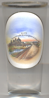
The  Promenade des Anglais [left, no. 4364]
along the Mediterranean coast of Nice extends from the airport on the west to the Quai des États-Unis on the east, for
a distance of approximately 7 kilometres. Administratively, it forms part of Route nationale 98, which runs between
Toulon and Menton. Starting in the second half of the 18th century, the English aristocracy took to spending the winter in Nice,
enjoying the panorama along the coast. In 1820, when a particularly harsh winter further north brought an influx of beggars to
Nice, some of the English proposed that they could work on the construction of a walkway along the sea. The city of Nice, intrigued
by the prospect of a pleasant promenade, greatly increased the scope of the work. The Promenade was first called the Camin deis
Anglés by the Niçois in their native dialect. After the annexation of Nice by France in 1860 it was renamed
Promenade des Anglais.
On 14 July 2016, a truck was deliberately driven at revellers celebrating Bastille Day on the Promenade. The driver, Mohamed
Lahouaiej-Bouhlel, also shot at others before crossing the road in the vehicle to continue the assault. The vehicle was surrounded
by police near the Palais de la Méditerranée, and Bouhlel was shot dead. 86 were killed, and 434 were wounded.
Promenade des Anglais [left, no. 4364]
along the Mediterranean coast of Nice extends from the airport on the west to the Quai des États-Unis on the east, for
a distance of approximately 7 kilometres. Administratively, it forms part of Route nationale 98, which runs between
Toulon and Menton. Starting in the second half of the 18th century, the English aristocracy took to spending the winter in Nice,
enjoying the panorama along the coast. In 1820, when a particularly harsh winter further north brought an influx of beggars to
Nice, some of the English proposed that they could work on the construction of a walkway along the sea. The city of Nice, intrigued
by the prospect of a pleasant promenade, greatly increased the scope of the work. The Promenade was first called the Camin deis
Anglés by the Niçois in their native dialect. After the annexation of Nice by France in 1860 it was renamed
Promenade des Anglais.
On 14 July 2016, a truck was deliberately driven at revellers celebrating Bastille Day on the Promenade. The driver, Mohamed
Lahouaiej-Bouhlel, also shot at others before crossing the road in the vehicle to continue the assault. The vehicle was surrounded
by police near the Palais de la Méditerranée, and Bouhlel was shot dead. 86 were killed, and 434 were wounded.
The Jetée-Promenade (Jetty-Promenade) [background left] was an old building,
built on stilts over the sea facing the public garden in 1882. It had a playful and tourist vocation to satisfy the tourists, English
in particular, who flocked to the Côte d'Azur . Nice's pier was largely inspired by the Royal Suspension Chain Pier at Brighton.
During World War I, the building was requisitioned and converted into a convalescent center for the wounded, like most hotels in
Nice. At the end of the war it was assigned to the American YMCA and used in 1918–-1919 as a reception center for American troops
on leave awaiting repatriation across the Atlantic. During World War II, in 1942, the Jetée-Promenade was forced to close.
The Casino de la Jetée was subsequently stripped in 1943–1944 of all its copper, bronze, statues, silverware, electrical
wiring and other metals likely to serve the German war effort. The German Wehrmacht finally odered the dismantling of the building's
superstructure in January 1944.
[https://de.wikipedia.org/wiki/Nizza, https://en.wikipedia.org/wiki/Nice;
https://en.wikipedia.org/wiki/Promenade_des_Anglais;
https://fr.wikipedia.org/wiki/Jet%C3%A9e-Promenade_de_Nice]
![[scale]](lineal.jpg)