
|
|
| UNITED KINGDOM OF GREAT BRITAIN AND NORTHERN IRELAND |
| England |
| Region: North East England |
| Metropolitan Borough: South Tyneside – Ceremonial County: Tyne and Wear |
map →
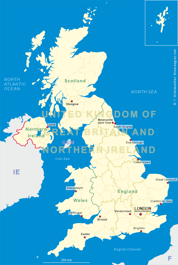
South Shields is a coastal town in South Tyneside, Tyne and Wear, England, situated on the south bank of the mouth of the River Tyne. The town has a population of about 75,300 (2021). It is the fourth largest settlement in Tyne and Wear, after Newcastle upon Tyne, Sunderland and Gateshead.
 The first evidence of a settlement within what is now the town of South Shields dates from pre-historic times. The Romans built the garrison
Arbeia around AD 160 and expanded it around AD 208. The fort was abandoned as the Roman Empire declined in the 4th century. Many
ruins still exist today and some structures have been rebuilt as part of a modern museum and popular tourist attraction. Thereafter, the place became
known as Caer Urfa and is believed to have become a royal residence. The current town was founded in 1245 and developed as a fishing port.
The name South Shields developed from the 'Schele' or 'Shield', which was a small dwelling used by fishermen. Another industry that was
introduced, was that of salt-panning, later expanded upon in the 15th century. During the English Civil War, the town in 1644 was seized by
Parliament's Scottish Covenanter allies in the course of their raids and ongoing siege of the heavily fortified Newcastle upon Tyne. In the
19th century, coal mining, alkaline production and glass making led to a boom in the town. In 1832, with the Great Reform Act, South Shields
and Gateshead were each given their own Member of Parliament and became boroughs, resulting in taxes being paid to the Government instead of the
bishops of Durham. During World War I, German Zeppelin airships bombed South Shields in 1916. Later during World War II, the German Luftwaffe
repeatedly attacked the town and caused massive damages. Gradually throughout the late 20th century, the coal and shipbuilding industries were
closed, due to competitive pressures from more cost-effective sources of energy (including workers) and more efficient shipbuilding elsewhere in
Eastern Europe and in South East Asia.
The first evidence of a settlement within what is now the town of South Shields dates from pre-historic times. The Romans built the garrison
Arbeia around AD 160 and expanded it around AD 208. The fort was abandoned as the Roman Empire declined in the 4th century. Many
ruins still exist today and some structures have been rebuilt as part of a modern museum and popular tourist attraction. Thereafter, the place became
known as Caer Urfa and is believed to have become a royal residence. The current town was founded in 1245 and developed as a fishing port.
The name South Shields developed from the 'Schele' or 'Shield', which was a small dwelling used by fishermen. Another industry that was
introduced, was that of salt-panning, later expanded upon in the 15th century. During the English Civil War, the town in 1644 was seized by
Parliament's Scottish Covenanter allies in the course of their raids and ongoing siege of the heavily fortified Newcastle upon Tyne. In the
19th century, coal mining, alkaline production and glass making led to a boom in the town. In 1832, with the Great Reform Act, South Shields
and Gateshead were each given their own Member of Parliament and became boroughs, resulting in taxes being paid to the Government instead of the
bishops of Durham. During World War I, German Zeppelin airships bombed South Shields in 1916. Later during World War II, the German Luftwaffe
repeatedly attacked the town and caused massive damages. Gradually throughout the late 20th century, the coal and shipbuilding industries were
closed, due to competitive pressures from more cost-effective sources of energy (including workers) and more efficient shipbuilding elsewhere in
Eastern Europe and in South East Asia.
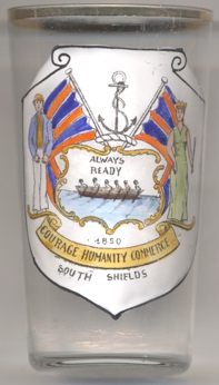
The decoration on glass no. 4396 [left] shows the coat of arms which was the  crest
crest
[https://en.wikipedia.org/wiki/South_Shields;
https://drawshield.net/reference/public-arms/s/south-shields.html,
https://www.shieldsgazette.com/news/politics/council/weathered-south-shields-coat-of-arms-to-be-replaced-on-the-customs-house-3880220]
![[scale]](lineal.jpg)