
|
|
| BRASIL | BRAZIL |
| estado: Bahia |
map →
Salvador is the capital city of the Brazilian state of Bahia. With more than 2.9 million inhabitants as of 2020, it is the most populous municipality in the Northeast, the third most populous in Brazil (Brasília surpassed Salvador in 2016, but it is a federal district, not a municipality), and the ninth largest Latin American city. It is the core of the metropolitan area known as "Great Salvador", which had almost 4 million inhabitants in 2020.
 Salvador lies on a small, roughly triangular peninsula that separates the Bay of All Saints, the largest bay in Brazil, from the Atlantic Ocean. It
was first reached by Gaspar de Lemos in 1501, just one year after Pedro Álvares Cabral's purported discovery of Brazil. In 1534, the settlement
of Pereira in modern Salvador's Ladeira da Barra neighbourhood was established. However, mistreatment of the Tupinambá by the settlers caused them
to turn hostile and the Portuguese were forced to flee to Porto Seguro c. 1546. The present city was established as the fortress of
São Salvador da Bahia de Todos os Santos ("Holy Saviour of the Bay of All Saints") in 1549. In 1551, Salvador became the seat of the first
Roman Catholic diocese erected in Brazil. In 1572, the Governorate of Brazil was divided into the separate governorates of Bahia in the north and
Rio de Janeiro in the south. These were reunited as Brazil six years later, then redivided from 1607 to 1613. In 1763, the
colonial administration was removed to Rio de Janeiro and elevated to a viceroyalty. Salvador remained the heart of the Recôncavo, Bahia's rich
agricultural maritime district, but was largely outside Brazil's early modernization. Owing to whales' use of the Bay of All Saints as a mating ground,
Salvador became a large whaling port in the Southern Hemisphere during the 19th century but the trade had already begun to fall off by the 1870s. Under
the empire and republic periods, however, the town slowly began to industrialise. In 1985, UNESCO listed the city's Pelourinho neighbourhood as a World
Heritage Site
(see also list of other UNESCO heritage sites depicted on glasses of this collection).
Salvador lies on a small, roughly triangular peninsula that separates the Bay of All Saints, the largest bay in Brazil, from the Atlantic Ocean. It
was first reached by Gaspar de Lemos in 1501, just one year after Pedro Álvares Cabral's purported discovery of Brazil. In 1534, the settlement
of Pereira in modern Salvador's Ladeira da Barra neighbourhood was established. However, mistreatment of the Tupinambá by the settlers caused them
to turn hostile and the Portuguese were forced to flee to Porto Seguro c. 1546. The present city was established as the fortress of
São Salvador da Bahia de Todos os Santos ("Holy Saviour of the Bay of All Saints") in 1549. In 1551, Salvador became the seat of the first
Roman Catholic diocese erected in Brazil. In 1572, the Governorate of Brazil was divided into the separate governorates of Bahia in the north and
Rio de Janeiro in the south. These were reunited as Brazil six years later, then redivided from 1607 to 1613. In 1763, the
colonial administration was removed to Rio de Janeiro and elevated to a viceroyalty. Salvador remained the heart of the Recôncavo, Bahia's rich
agricultural maritime district, but was largely outside Brazil's early modernization. Owing to whales' use of the Bay of All Saints as a mating ground,
Salvador became a large whaling port in the Southern Hemisphere during the 19th century but the trade had already begun to fall off by the 1870s. Under
the empire and republic periods, however, the town slowly began to industrialise. In 1985, UNESCO listed the city's Pelourinho neighbourhood as a World
Heritage Site
(see also list of other UNESCO heritage sites depicted on glasses of this collection).
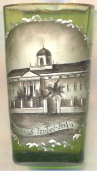
The  Hospital Santa Izabel [left, no. 4424] is located in the neighbourhood of Lazaré.
Its origins date back to the former Hospital de Charidade da Santa Casa da Misericórdia, founded together with the city of Salvador in 1549 and
which operated where today the Santa Casa Museum is located. In 1814, the need to increase the facilities was already being discussed, but it was only
after the War of Independence (1821–1824) that the Brotherhood acquired a new property. With the acquisition carried out in 1828, the cornerstone
was laid in the same year, but works were interrupted in the following year. Resumed in 1837, the project, following the design of the Dutch architect
Pedro Weyll, was finally completed in 1893.
Hospital Santa Izabel [left, no. 4424] is located in the neighbourhood of Lazaré.
Its origins date back to the former Hospital de Charidade da Santa Casa da Misericórdia, founded together with the city of Salvador in 1549 and
which operated where today the Santa Casa Museum is located. In 1814, the need to increase the facilities was already being discussed, but it was only
after the War of Independence (1821–1824) that the Brotherhood acquired a new property. With the acquisition carried out in 1828, the cornerstone
was laid in the same year, but works were interrupted in the following year. Resumed in 1837, the project, following the design of the Dutch architect
Pedro Weyll, was finally completed in 1893.
[https://en.wikipedia.org/wiki/Salvador,_Bahia;
https://pt.wikipedia.org/wiki/Hospital_Santa_Izabel]
![[scale]](lineal.jpg)